本文已被:浏览 953次 下载 3783次
投稿时间:2022-01-25 修订日期:2022-05-14
投稿时间:2022-01-25 修订日期:2022-05-14
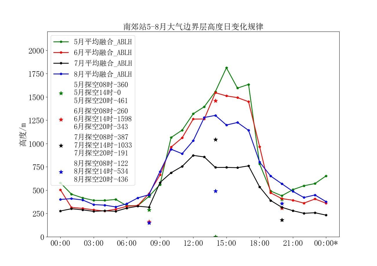
中文摘要: 利用北京国家综合气象探测试验基地超大城市观测试验建设的地基垂直遥感设备(激光气溶胶雷达、微波辐射计及风廓线雷达),使用2021年5—8月的观测资料,根据不同设备的探测优势以及边界层的日变化规律,利用激光气溶胶雷达、微波辐射计、风廓线雷达观测资料进行联合反演,得到全天候大气边界层高度。并将联合反演所得的边界层高度与探空资料计算及ERA5再分析资料提供的全天候大气边界层高度进行比较,发现:联合反演边界层高度与ERA5数据提供的大气边界层高度有较好的一致性;激光气溶胶雷达适用于白天对流边界层的观测,微波辐射计适用于夜间稳定边界层的观测,使用微波辐射计与风廓线雷达联合反演大气边界层高度可以改善弱降雨时单设备的反演结果;联合反演的大气边界层高度结果与单设备反演大气边界层高度均符合大气边界层的日变化规律;得到的联合反演边界层高度与探空数据计算得到的大气边界层高度差值的标准偏差为62 m,相较于ERA5数据提供的一定范围内大气边界层高度均值,联合反演边界层高度能更精准地反映更小范围内的大气边界层高度。
Abstract:By using the ground-based vertical remote sensing equipment constructed by the Beijing National Comprehensive Meteorological Observation and Test Base for the Super-Large City Observation Test, and the observation data of radiosonde, laser aerosol radar, microwave radiometer and wind profiler radar from May to August 2021, and according to different detection advantages of the equipment and the diurnal variation of the boundary layer, this paper performs the joint inversion to the observation data of laser aerosol radar, microwave radiometer, and wind profiler radar to obtain the all-weather atmospheric boundary layer height. The comparison of the height of the boundary layer obtained from the joint inversion with the height of the all-weather atmospheric boundary layer provided by the sounding data calculation and the ERA5 reanalysis data suggests that the joint inversion boundary layer height is in good agreement with the atmospheric boundary layer height provided by the ERA5 data. The laser aerosol radar is suitable for the observation of the convective boundary layer during the daytime, and the microwave radiometer is suitable for the observation of the stable boundary layer at night. The use of microwave radiometer and wind profiler radar to jointly retrieve the height of the atmospheric boundary layer can improve the performance of a single device during rainfall. The joint inversion of the atmospheric boundary layer height result and the single device inversion of the atmospheric boundary layer height are in line with the diurnal variation of the atmospheric boundary layer. The joint inversion of boundary layer height obtained in this article is compared with the height difference of the atmospheric boundary layer from the sounding data, and their standard deviation is 62 m. Compared with the average value of the atmospheric boundary layer height in a certain range provided by the ERA5 data, the joint inversion of the boundary layer height could more accurately reflect the atmospheric boundary layer height in a smaller range.
文章编号: 中图分类号: 文献标志码:
基金项目:国家重点研发计划(2017YFC15017000)资助
引用文本:
杨世昆,杨玲,张雪芬,陶法,何平,茆佳佳,焦志敏,徐文铎,2023.地基遥感联合反演大气边界层高度与ERA5再分析资料比对分析[J].气象,49(2):178-187.
YANG Shikun,YANG Ling,ZHANG Xuefen,TAO Fa,HE Ping,MAO Jiajia,JIAO Zhimin,XU Wenduo,2023.Comparison and Analysis of Atmospheric Boundary Layer Height Retrieved by Ground-Based Remote Sensing and ERA5 Reanalysis Data[J].Meteor Mon,49(2):178-187.