本文已被:浏览 1258次 下载 6259次
投稿时间:2019-01-08 修订日期:2019-11-17
投稿时间:2019-01-08 修订日期:2019-11-17
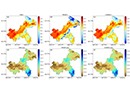
中文摘要: 为探索考虑地形的空间插值算法在复杂下垫面地区的适用性,利用重庆市区域自动气象站2017年逐月观测数据,采用Cokriging、PRISM和IDW三种算法进行了1 km分辨率插值试验,并分析对比了其在月累积降水、月平均气温插值中的误差。结果表明,当样本数量较多时,平均气温的插值以PRISM误差相对较小,Cokriging和IDW效果相当;对累积降水的插值,PRISM和Cokriging效果相当,并略优于IDW。三种算法的误差均随样本数量减少而增大,但PRISM的平均气温误差增长相对最慢,累积降水误差增长相对最快。当样本数量较少时,PRISM对气温插值的误差相对最小,而Cokriging对降水的插值误差相对最小。进一步分析表明:PRISM能显著减少复杂地形区的气温插值误差;累积降水插值主要受降水强度及降水局地性影响,考虑地形的插值算法并无明显优势。
中文关键词: 空间插值,PRISM,Cokriging,IDW
Abstract:To explore the applicability of terrain-considered spatial interpolation method in complex underlying surface region, the interpolation tests using regional automatic weather station observation data of monthly accumulated precipitation and average temperature in Chongqing in 2017 were designed by Cokriging, PRISM and IDW interpolation methods. The results showed that when a large number of samples are used, for average temperature, Cokriging and IDW have similar interpolation errors, which are lager than PRISM’s. For accumulated precipitation, two terrain-considered methods have similar errors and both are slightly lower than IDW. The accuracy of all three methods would decrease when using fewer observation samples, but PRISM has the lowest decrement rate in average temperature interpolation and highest decrement rate in precipitation interpolation. PRISM and Cokriging have the lowest errors for temperature and precipitation respectively when using small amounts of samples. Further analysis shows that PRISM can reduce the temperature interpolation error of complex terrain region significantly, but since the errors of accumulated precipitation are mainly based on precipitation intensity, the terrain-considered interpolation method may not have obvious advantage.
文章编号: 中图分类号: 文献标志码:
基金项目:国家自然科学基金项目(41875111)、重庆市气象局智慧气候应用创新团队项目(ZHCXTD-201807、ZHCXTD-201916)和中国气象局气候变化专项(CCSF202020)共同资助
| 作者 | 单位 |
| 朱浩楠 | 重庆市气候中心,重庆 401147 |
| 刘晓冉 | 重庆市气候中心,重庆 401147 |
| 李永华 | 重庆市气候中心,重庆 401147 |
| 廖代强 | 重庆市气候中心,重庆 401147 |
| 张芬 | 重庆市气候中心,重庆 401147 |
引用文本:
朱浩楠,刘晓冉,李永华,廖代强,张芬,2020.考虑地形的空间插值算法在复杂下垫面地区气温和降水精细化插值的评估[J].气象,46(5):655-665.
ZHU Haonan,LIU Xiaoran,LI Yonghua,LIAO Daiqiang,ZHANG Fen,2020.Evaluation of Terrain-Considered Spatial Interpolation Methods on Temperature and Precipitation in Complex Underlying Surface Region[J].Meteor Mon,46(5):655-665.