本文已被:浏览 1021次 下载 4406次
投稿时间:2019-01-16 修订日期:2020-02-09
投稿时间:2019-01-16 修订日期:2020-02-09
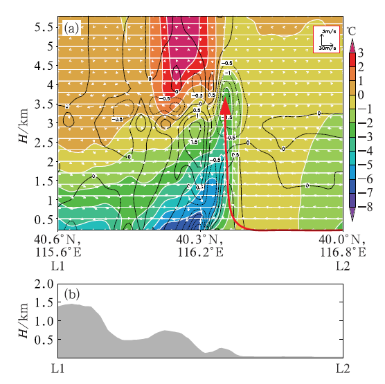
中文摘要: 利用北京地区稠密的观测资料和变分多普勒雷达分析系统(VDRAS)再分析资料,分析了2017年7月7日相继影响北京地区并造成短时强降水、大风、小冰雹等的两条线状对流活动。两条对流均生成于北京西北的河北张家口山区,且在山脚和平原地区继续发展,但其边界层条件是不同的,第二条对流带在第一条影响后的冷垫上发展。结果表明:平原及山脚一带较好的热力、动力条件,包括高温高湿的边界层环境、低层环境风场与对流带前侧冷池出流形成的辐合,为第一条对流带在下山过程中快速组织化发展形成飑线提供了有利条件。飑线发展强盛阶段,冷池的发展与环境低层垂直风切变达到平衡,冷池前沿自地面至1.5 km高度处形成强辐合区,上升运动呈近乎垂直的形态。第二条对流带在前一条飑线形成的冷垫上继续发展,形成暖季高架对流,虽然风暴上升运动呈倾斜状且强度有所减弱,但是强回波(≥45 dBz)面积未减。一方面,第二条对流带受前一条飑线能量方面的抑制;但另一方面,两条对流带在合适的距离下,低层流场形成辐合,尤其是在第二条对流带的冷池与前一条飑线形成的冷垫靠近叠加以后低层辐合进一步加强,第二条对流带回波继续北上。本例高架对流发展的能量来源主要为边界层以上层结不稳定的大气,可能伴随在第一条飑线过境后由偏南暖湿气流带来的边界层以上对流能量重建过程。所以,在强对流短时临近预报业务中,需要综合考虑热力、动力等多重因素,而VDRAS快速更新同化的再分析资料可以提供有效参考。
中文关键词: 线状对流,高架对流,边界层,VDRAS,对流能量重建
Abstract:Two line convections hit Beijing Area successively and caused short time heavy rainfalls, gales and small hails on 7 July 2017. In this paper, the two cases were compared based on the high spatio temporal resolution observations and the Variational Doppler Radar Analysis System (VDRAS) dataset. Both of the line convections were formed on the mountains in Zhangjiakou, located to the northwest of Beijing, and developed at the foothills and on the plains. However, they had different boundary layer conditions, as the second one developed on the cold mass caused by the first one. The results are shown as follows. The first line convection developed into a squall line benefited from both dynamic and thermodynamic conditions of the foothills and the plains, which includes the hot and humid environment in the boundary layer, the convergence line generated by the outflows of the cold pool and the low level environmental southerly wind. At its mature phase, the squall line had the strongest convergence from surface to the height of 1.5 km and an approximately vertical updraft. The second line convection developed into an elevated convection on the cold mass caused by the previous one. The area of strong echo (≥45 dBz) maintained, though the updraft tilted and had a certain decrease. The thermodynamic conditions seemed to be no longer beneficial due to the wide and strong cold mass caused by the first one. The outflows from the two lines formed a convergence line, and the convergence line intensified especially when the cold mass of the second one met the cold mass caused by the first one, which offered dynamic conditions for the second one. The unstable layer above the boundary layer provided convective energy for the elevated convection. Besides, the rebuilt of convective available potential energy (CAPE) after the first convection is possible as warm advection and positive water vapour transport did exist in Beijing Area. Above all, both dynamic and thermodynamic conditions should be 〖JP2〗considered in nowcasting of convective storms, where VDRAS could play a positive role.
文章编号: 中图分类号: 文献标志码:
基金项目:国家重点研发计划(2018YFC1507305)和中央级公益性科研院所基本科研业务费专项(IUMKY201812)共同资助
引用文本:
纪彬,何静,张迎新,周璇,2020.北京地区两条线状对流相继下山发展的边界层条件对比研究[J].气象,46(5):643-654.
JI Bin,HE Jing,ZHANG Yingxin,ZHOU Xuan,2020.Study on Two Successive Downhill Line Convections Developing on Different Boundary Layer Conditions in Beijing Area[J].Meteor Mon,46(5):643-654.
纪彬,何静,张迎新,周璇,2020.北京地区两条线状对流相继下山发展的边界层条件对比研究[J].气象,46(5):643-654.
JI Bin,HE Jing,ZHANG Yingxin,ZHOU Xuan,2020.Study on Two Successive Downhill Line Convections Developing on Different Boundary Layer Conditions in Beijing Area[J].Meteor Mon,46(5):643-654.