本文已被:浏览 1293次 下载 3797次
投稿时间:2018-07-02 修订日期:2019-09-16
投稿时间:2018-07-02 修订日期:2019-09-16
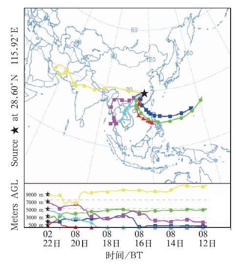
中文摘要: 利用常规高空、地面观测资料,分析了2015年6月22日南昌大暴雨过程的环流背景和主要影响系统;利用HYSPLIT模式和6 h一次的NCEP 1°×1°再分析场资料模拟了大暴雨过程240 h气块的后向轨迹,并对中低层的轨迹进行了聚类分析,讨论了不同层次气块在移动过程中水汽的变化。结论:(1)此次大暴雨过程发生在500 hPa低槽前与副热带高压外围的西南气流中、南海海域有1508号热带风暴鲸鱼的背景下,中低层有低涡、切变线及低空急流和地面冷锋,高空200 hPa存在风向分流辐散,且南昌上空有位势不稳定层结等对流性降水特征。(2)轨迹聚类分析表明暴雨过程中水汽路径总体上可以归纳为6条,源自西北太平洋西部、位于1500 m以上的层次,占180条轨迹的46.7%;其次是从南海东部北上而来,位于3000 m以下的层次,占24.4%;还有孟加拉湾东部、中南半岛南部和云南南部等西南方向的通道,占11.7%;其他3条路径均不足9%。(3)对不同层次气块水汽含量的定量分析发现,源自西北太平洋西部和南海东部近海面的气块水汽含量大,到达1500、500 m上空时比湿仍然较高,因而对暴雨的贡献大。南昌3000 m上空气块初始时来自西北太平洋中部相对干的空气,但到达南昌上空时水汽含量显著增大,对暴雨水汽输送贡献也较大。在副热带高压脊线稳定维持且南海有热带风暴存在的背景下,沿副热带高压底部偏东南或偏东气流导致的水汽输送对江南北部暴雨的发生非常重要。
中文关键词: 热带气旋,暴雨,水汽,轨迹,南昌
Abstract:Analysis of the rainstorm on 22 June 2015 in Nanchang was carried out using conventional observations. Backward trajectories up to 240 h were simulated and studied based on the HYSPLIT model and the NCEP 6 h 1°×1° reanalysis data. Cluster analysis of mid-low level trajectories was performed to analyze the change of moisture content of air parcels. The results showed that (1) the rainstorm developed ahead of the 500 hPa trough and the northwestern periphery of subtropical high. Tropical cyclone “Kujira” in the South China Sea also induced low-pressure systems, shear lines, low-level jets in the mid-low levels and divergence at 200 hPa. The rainstorm was located near a cold front with little potential instability and weak vertical wind shear. (2) In general, six major paths of moisture transport were found by clustering. Water vapor mainly came from the western part of Western North Pacific (46.7% of 180 backward trajectories) above 1500 m, followed by the eastern part of the South China Sea (24.4%) below 3000 m. 11.7% of the trajectories were originated from the east of the Bay of Bengal, the south of Indochina Peninsula and the south of Yunnan Province of China, and the remaining three clusters constituted less than 9%. (3) Air parcels from the two major clusters were observed to have higher moisture content as they were close to the surface over their maritime origins, which made the air parcels still have high specific humidity and relative humidity when they reached Nanchang, thus contributing greatly to the rainstorm. Air parcel that ended up in Nanchang over 3000 m and came from the Western North Pacific was originally dry in nature, but it became much more humid after it subsided and picked up moisture. With steady subtropical high and a tropical cyclone in the South China Sea just south of the subtropical high, moisture brought along by the easterlies or southeasterlies at the periphery of the high was an essential ingredient of rainstorms in the northern part of Jiangnan Region.
文章编号: 中图分类号: 文献标志码:
基金项目:中国气象局气象预报业务关键技术发展专项(YBGJXM2018-02-12)、中国气象局预报员专项(CMAYBY2018-096)和江西省气象局重点科研项目“江西省降水格点预报客观订正技术研究”共同资助
引用文本:
许彬,熊秋芬,张玉婷,2019.一次热带风暴背景下南昌暴雨的水汽来源及输送特征[J].气象,45(10):1392-1401.
XU Bin,XIONG Qiufen,ZHANG Yuting,2019.Analysis of Moisture Source and Transport Pathways of a Rainstorm with Tropical Cyclone in Nanchang[J].Meteor Mon,45(10):1392-1401.
许彬,熊秋芬,张玉婷,2019.一次热带风暴背景下南昌暴雨的水汽来源及输送特征[J].气象,45(10):1392-1401.
XU Bin,XIONG Qiufen,ZHANG Yuting,2019.Analysis of Moisture Source and Transport Pathways of a Rainstorm with Tropical Cyclone in Nanchang[J].Meteor Mon,45(10):1392-1401.