本文已被:浏览 1194次 下载 4238次
投稿时间:2018-03-20 修订日期:2018-11-13
投稿时间:2018-03-20 修订日期:2018-11-13
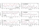
中文摘要: 利用2008—2015年冀东地区发生的36个冰雹个例,通过秦皇岛多普勒天气雷达资料反演出冰雹发生时雷达的各种参数,提取各种参数与冰雹发生时的关系。研究结果表明冰雹发生时,基于风暴的最大基本反射率因子、风暴顶高、垂直累积液态水含量平均值分别为62 dBz,9.9 km,51.6 kg?m-2,0℃层以上平均风暴厚度为5.8 km,0℃层和-20℃层之间厚度平均值为3.1 km,风暴最大基本反射率因子所在高度为4.6 km,风暴平均移动速度为9 m?s-1。不同尺寸的冰雹雷达参数变化不大。在冰雹发生过程中,两个体扫间风暴的最大基本反射率因子平均最大跃变为7 dBz,风暴顶高平均最大跃变为6.7 km,垂直累积液态水含量平均最大跃变为17 kg?m-2,这种跃变的出现比冰雹发生时刻平均提前39、30和25 min,可以作为冰雹发生前的重要判断依据。此外还对WSR 88D冰雹算法进行了评估,结果表明,该算法的命中率较高,虚警率也较高,算法对冰雹的预报提前量平均为43 min左右,冰雹尺寸的预报结果偏大。
中文关键词: 冰雹,雷达参数,冰雹指数,0℃层高度
Abstract:Various parameters are inversed when hail occurred by using Qinhuangdao Doppler weather radar data, and the relationship between various parameters and occurrence of hailstorms is extracted with 36 hailstorm cases during 2008-2015 in the eastern Hebei Province. The study results show that the averages of maximum radar base reflectivity (MaxREF), top of the storm (TOP) and vertically integrated liquid (VIL) are 62 dBz, 9.9 km and 51.6 kg?m-2 respectively when hails occur. The average storm thickness above 0℃ level layer is 5.8 km, the average thickness between 0℃ level layer and -20℃ level layer is 3.1 km, MaxREF height of the storm is 4.6 km, and the average storm moving speed is 9 m?s-1. The radar parameters corresponding to different sizes of hailstones do not change significantly. During the occurrence of hail, sudden increase phenomenon for MaxREF between the two volume scan is 7 dBz on average, sudden increase phenomenon for TOP between the two volumn scans is 6.7 km on average and sudden increase phenomenon for VIL between the two volumn scans is 17 kg?m-2 on average. This transition occurred 39, 30 and 25 min earlier than the average time of hailstorm occurrence. Such sepcical phenonmenon could be an important criterion for hail warning. In addition, the WSR 88D hail algorithm HI is evaluated. The results show that probability of detection and false acceptance rate of the hail algorithm are relatively higher. The forecasting rate of hail by the algorithm is about 43 min on average, and the hail forecast results are larger.
文章编号: 中图分类号: 文献标志码:
基金项目:河北省气象局青年基金项目(18ky34)资助
| 作者 | 单位 |
| 王莎 | 秦皇岛市气象局,秦皇岛 066000 |
| 沙勇 | 中国华云气象科技集团公司,北京 100081 |
| 宋金妹 | 秦皇岛市气象局,秦皇岛 066000 |
| 裴宇杰 | 河北省气象台,石家庄 050021 |
| 吴林林 | 安徽省人工影响天气办公室,合肥 230031 |
引用文本:
王莎,沙勇,宋金妹,裴宇杰,吴林林,2019.冀东地区冰雹云多普勒雷达参数特征分析[J].气象,45(5):713-722.
WANG Sha,SHA Yong,SONG Jinme,PEI Yujie,WU Linlin,2019.Characteristic Analysis of Hail Cloud Doppler Radar Parameters in the Eastern Hebei Province[J].Meteor Mon,45(5):713-722.
王莎,沙勇,宋金妹,裴宇杰,吴林林,2019.冀东地区冰雹云多普勒雷达参数特征分析[J].气象,45(5):713-722.
WANG Sha,SHA Yong,SONG Jinme,PEI Yujie,WU Linlin,2019.Characteristic Analysis of Hail Cloud Doppler Radar Parameters in the Eastern Hebei Province[J].Meteor Mon,45(5):713-722.