本文已被:浏览 819次 下载 4920次
投稿时间:2020-12-08 修订日期:2021-12-30
投稿时间:2020-12-08 修订日期:2021-12-30
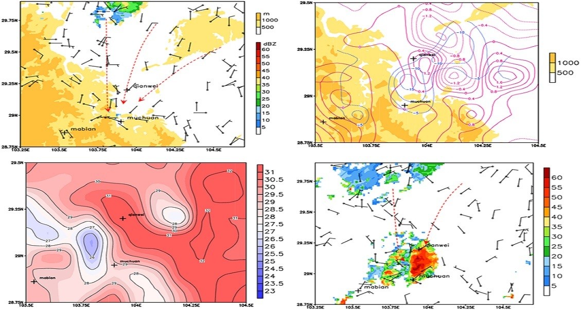
中文摘要: 2018年5月21日夜间,四川盆地西南部至南部地区发生了5月罕见的大暴雨,主客观预报均明显偏弱。采用多种观测资料及模式分析场和预报场数据,对极端大暴雨的环流背景、中尺度对流系统触发和发展机制以及预报偏差可能的原因等进行了分析。此次大暴雨过程发生在西太平洋副热带高压西伸、异常偏强的蒙古冷涡引导冷空气南下的背景下,四川盆地南部的水汽和不稳定能量均较常年同期异常偏强,具备产生对流性强降水的极高潜势。高分辨率观测和分析资料揭示出四川盆地周边特殊地形对中尺度对流系统发生发展的动力和热力机制。偏北风在喇叭口和地形过渡区辐合抬升、在峡谷地带绕流形成中尺度辐合线或中尺度低压;由地形或上游强降水造成的降温加大了盆地西部和南部边缘的温度梯度,并在温度梯度大值区附近产生上升运动。盆地西南部持续偏北风辐合,加之地形阻挡,使得对流系统移动缓慢,累计降水量增大;而盆地南部对流的维持则主要受到天气尺度系统的影响。欧洲中心数值模式对盆地内对流层低层风场结构以及盆地周边复杂地形刻画的偏差,可能是导致对流性强降水预报明显偏弱的重要原因。
Abstract:A rare extreme rainstorm occurred in Sichuan Basin on 21 May 2018. Both subjective and objective forecasts failed to capture this disastrous event. In this study, the large scale circulation, the triggering and developing mechanisms of mesoscale systems and the possible causes of forecast biases are analyzed based on the observational and reanalysis data. During this extreme rainstorm event, the westward extension of the western Pacific subtropical high and the abnormally strong Mongolia cold vortex jointly led to the southward invasion of the cold air. The water vapor and unstable energy in the southern Sichuan Basin were extremely stronger than normal, which favored the occurrence of convective heavy precipitation. The special topography near the Sichuan Basin was closely related to the triggering and maintaining of mesoscale convective systems. The northerly wind converged and was lifted up over the unique “bell mouth” terrain, forming a mesoscale convergence line and mesoscale low around the gorge. The temperature gradient on the west and south edges of the basin was increased due to the basin terrain and upwind heavy rainfall. Then, the ascending motion was induced in the large temperature gradient area. The persistent convergence of the northerly wind and the topographic obstruction made the convective systems move slowly, resulting in the increase of accumulated precipitation. However, the convections in the southern basin were mainly affected by the synoptic scale systems. The underestimate of convective precipitation by the EC model was possibly caused by the deviation of wind in the lower troposphere in the basin and the undetailed description of the basin terrain.
keywords: Sichuan Basin, extreme rainstorm, mesoscale convective system, cold air, terrain, forecast bias
文章编号: 中图分类号: 文献标志码:
基金项目:国家重点研发计划(2018YFC1505705)、国家自然科学基金重大研究计划集成项目(91937301)和国家气象中心预报员专项(Y201907)共同资助
引用文本:
张芳,张芳华,孔期,徐珺,陈涛,2022.2018年5月21日四川盆地极端大暴雨的中尺度成因和预报偏差分析[J].气象,48(6):691-704.
ZHANG Fang,ZHANG Fanghua,KONG Qi,XU Jun,CHEN Tao,2022.Mesoscale Mechanisms and Forecast Bias of the Extreme Rainstorm in Sichuan Basin on 21 May 2018[J].Meteor Mon,48(6):691-704.
张芳,张芳华,孔期,徐珺,陈涛,2022.2018年5月21日四川盆地极端大暴雨的中尺度成因和预报偏差分析[J].气象,48(6):691-704.
ZHANG Fang,ZHANG Fanghua,KONG Qi,XU Jun,CHEN Tao,2022.Mesoscale Mechanisms and Forecast Bias of the Extreme Rainstorm in Sichuan Basin on 21 May 2018[J].Meteor Mon,48(6):691-704.