本文已被:浏览 648次 下载 4171次
投稿时间:2020-08-02 修订日期:2021-06-30
投稿时间:2020-08-02 修订日期:2021-06-30
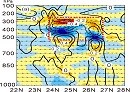
中文摘要: 利用常规气象站、自动站、NCEP/NCAR(美国国家环境预报中心/国家大气研究中心)的全球预报系统(GFS)分析资料、多普勒雷达和卫星等多种资料,对2015年7月29日和2018年7月14日两次过程对比分析后发现:两次过程在200 hPa 上均存在一个东风带涡旋,500 hPa是类似东风波的系统,850 hPa处于副热带高压环流中,因此这两次过程是在东风带高空冷涡背景下发生的。处于东风带中的涡旋系统与台风、东风波等系统显著不同,其垂直方向上并不深厚,主要位于对流层中上层,湿度较高但温度较低,系统本身不像台风或东风波那样会发生大风、暴雨等强烈天气。2015年7月29日中午在浙闽沿海因海洋、陆地风向风速差异以及高低层之间风向辐合等因素影响下,形成了东、西风之间的中尺度辐合线,随后中尺度辐合线触发或加强了对流天气;而2018年7月14日过程虽然具备了对流潜势,但由于缺乏低层的触发机制,最终没有发生强对流。高层冷涡西进时,冷涡前进方向高层的辐散式旋转特性增强了中低层的上升运动,有助于对流天气加强,这与西风带天气过程有明显差异,会给强对流的预报预警造成较大困难,应特别关注。
中文关键词: 高空冷涡,强对流,东风带,对比分析
Abstract:The comparative analysis of the severe convective weather processes on 29 July 2015 and 14 July 2018 is carried out based on conventional observation data, automatic weather station data, NCEP/NCAR GFS analysis data, Doppler radar data and satellite data. The results demonstrate that there was a cold vortex in easterlies at 200 hPa, an easterly wave at 500 hPa but subtropical high at 850 hPa in both cases, which means the weather events were under the influence of upper-tropospheric cold vortex in easterlies. The vortex in easterlies with shallow depth, high relative humility and low temperature was significantly different from typhoon or easterly wave. Furthermore, the cold vortex could not bring gale and rainstorm by itself. However, it inccurred severe convection with thunderstorm, heavy rain and hail triggered by surface mesoscale convergence line which was caused by east and west winds on 29 July 2015. On the contrary, there was no occurrence of convection due to the lack of trigger mechanism on 14 July 2018. The divergent rotation characteristics in front of the cold vortex moving could enhance the ascending motion so that it made the convection severely, which was significant different from the weather systems under westerlies. Therefore, it should be paid special attention to in the early-warning operation.
文章编号: 中图分类号: 文献标志码:
基金项目:中国气象局预报员专项(CMAYBY2019-047)和浙江省气象局青年项目(2019QN04)共同资助
| 作者 | 单位 |
| 沈杭锋 | 杭州市气象局,杭州 310051 |
| 林宏伟 | 浙江省慈溪市气象局,慈溪 315300 |
| 娄小芬 | 浙江省气象台,杭州 310017 |
| 崔洁 | 杭州市气象局,杭州 310051 |
| 张红蕾 | 浙江省气象科学研究所,杭州 310017 |
引用文本:
沈杭锋,林宏伟,娄小芬,崔洁,张红蕾,2021.两次东风带高空冷涡强对流天气对比分析[J].气象,47(11):1380-1390.
SHEN Hangfeng,LIN Hongwei,LOU Xiaofen,CUI Jie,ZHANG Honglei,2021.Comparative Analysis of Two Severe Convective Weather Events Under the Influence of Upper-Tropospheric Cold Vortex in Easterlies[J].Meteor Mon,47(11):1380-1390.
沈杭锋,林宏伟,娄小芬,崔洁,张红蕾,2021.两次东风带高空冷涡强对流天气对比分析[J].气象,47(11):1380-1390.
SHEN Hangfeng,LIN Hongwei,LOU Xiaofen,CUI Jie,ZHANG Honglei,2021.Comparative Analysis of Two Severe Convective Weather Events Under the Influence of Upper-Tropospheric Cold Vortex in Easterlies[J].Meteor Mon,47(11):1380-1390.