本文已被:浏览 853次 下载 2039次
投稿时间:2018-05-12 修订日期:2019-01-16
投稿时间:2018-05-12 修订日期:2019-01-16
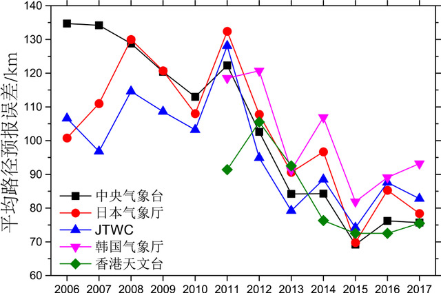
中文摘要: 以中国气象局上海台风研究所整编的最佳路径数据集为依据,对2017年西北太平洋和南海海域热带气旋定位精度及路径、强度和登陆点预报精度进行了评定。评定结果表明:2017年定位总平均误差为26.7 km,比2016年略偏大。无论是主观预报还是客观预报方法,近两年在72 h以内的路径预报整体水平并没有超越2015年。2017年,中央气象台除了对台风纳沙在台湾宜兰的24 h登陆点预报较差外,其余台风的24 h登陆点预报误差基本在65 km以下。采用不同机构的最佳路径或实时定位定强数据作为参考会对精度评定的结果产生较大影响。
中文关键词: 热带气旋,定位误差,路径误差,强度误差
Abstract:Operational positioning, track, intensity and landfall point forecast errors of tropical cyclones (TCs) over Western North Pacific and South China Sea in 2017 were evaluated on the base of CMA/STI’s best track dataset. The results show that the performance of TC positioning in 2017 was a little larger than in 2016, with an average error by all methods was 26.7 km. The overall track forecast accuracies within 72 h were not better than in 2015 in recent two years for both subjective and objective methods. Landfall prediction errors for the 24 h landfall point predictions of CMA were mainly less than 65 km, except for the landfall point of “Nesat” at Yilan Taiwan Province. The evaluation results could be strongly influenced by adopting different best tracks or operational real time observed dataset from different official agencies.
文章编号: 中图分类号: 文献标志码:
基金项目:国家自然科学基金项目(41575108和41405060)及江苏省高校研究生科技创新项目(No.KYZZ16_0932)共同资助
| 作者 | 单位 |
| 陈国民 | 中国气象局上海台风研究所,上海 200030 |
| 张喜平 | 中国气象局上海台风研究所,上海 200030 |
| 白莉娜 | 中国气象局上海台风研究所,上海 200030 |
| 万日金 | 中国气象局上海台风研究所,上海 200030 |
引用文本:
陈国民,张喜平,白莉娜,万日金,2019.2017年西北太平洋和南海热带气旋预报精度评定[J].气象,45(4):577-586.
CHEN Guomin,ZHANG Xiping,BAI Lina,WAN Rijin,2019.Verification on Forecasts of Tropical Cyclones over Western North Pacific and South China Sea in 2017[J].Meteor Mon,45(4):577-586.
陈国民,张喜平,白莉娜,万日金,2019.2017年西北太平洋和南海热带气旋预报精度评定[J].气象,45(4):577-586.
CHEN Guomin,ZHANG Xiping,BAI Lina,WAN Rijin,2019.Verification on Forecasts of Tropical Cyclones over Western North Pacific and South China Sea in 2017[J].Meteor Mon,45(4):577-586.