本文已被:浏览 227次 下载 1473次
投稿时间:2024-07-01 修订日期:2025-04-16
投稿时间:2024-07-01 修订日期:2025-04-16
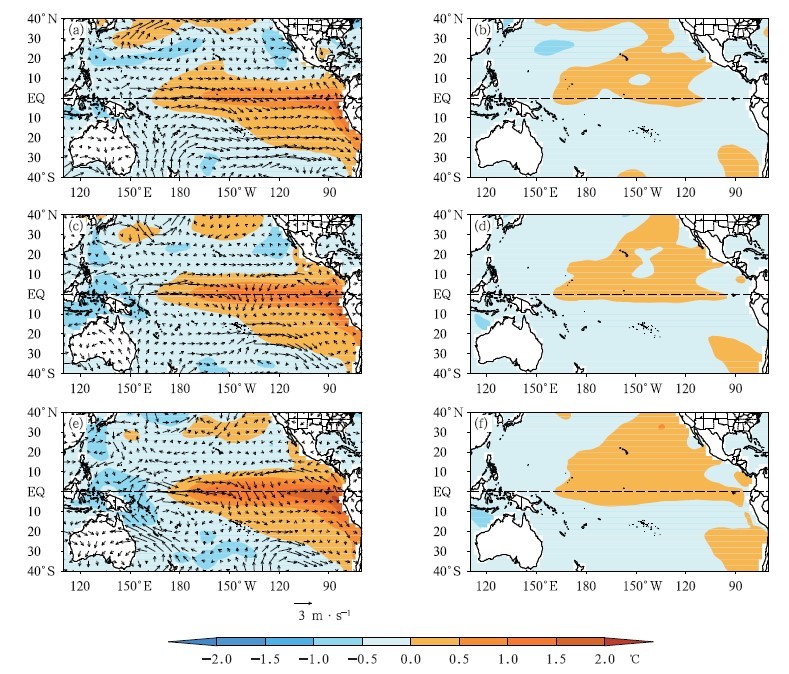
中文摘要: 基于1961—2023年中国643个站月降水量、NCAR/NCEP再分析资料和NOAA ERSST海面温度(SST)资料,分析了厄尔尼诺开始早晚对中国夏季降水的影响。结果表明:厄尔尼诺开始较早年夏季赤道中西太平洋异常西风明显强于开始较晚年,开始较早年赤道中东太平洋SST增暖更为明显,季内SST持续上升;而开始较晚年赤道中东太平洋暖SST不明显且发展缓慢。厄尔尼诺开始较早年和较晚年中国中东部夏季降水有明显的差异,其中7月和8月差异最为明显。厄尔尼诺开始较早年西北太平洋异常反气旋(WNPAC)一般在8月前后出现,中东部夏季降水从南到北为“-+-”分布,江淮地区偏多,其他地区偏少。其中6月西太平洋为异常气旋,中国中东部大部降水偏少;7月西太平洋异常气旋明显南压,江南大部、西北地区、华北地区降水持续偏少,日本以东异常反气旋明显西伸南压,中国东南沿海转为异常偏南风,华南沿海、江淮流域降水转为偏多;8月西北太平洋转为异常反气旋,WNPAC开始出现,长江中下游及其以南大部降水偏多,我国北方大部降水偏少。开始较晚年WNPAC一般出现在10月或之后,6—8月西太平洋一直为异常气旋,中国中东部夏季降水从南到北为“+-+”分布,各月降水异常持续性特征明显。
中文关键词: 厄尔尼诺,夏季降水,西北太平洋异常反气旋(WNPAC)
Abstract:Based on the monthly precipitation of 643 stations in China, NCAR/NCEP reanalysis data and NOAA ERSST sea surface temperature (SST) data from 1961 to 2023, the impacts of early and late onset of El Nino on summer precipitation in China are analyzed. The results are as follows. Westerly wind anomalies in the equatorial West-Central Pacific are more pronounced in June-August of years with early El Nino onset than in years with late El Nino onset, resulting in a more obvious warming of SST in the equatorial East-Central Pacific in earlier onset years, and the SST in this period continues to rise. However, the positive anomaly of SST in the equatorial East-Central Pacific in the later onset years of El Nino is not obvious and changes slowly. There are obvious differences in summer precipitation in central and eastern China between the El Nino earlier and the El Nino later onset years, especially in July and August. In the El Nino earlier onset years, the Western North Pacific anomalous anticyclone (WNPAC) generally appears around August, the summer precipitation in central and eastern China is distributed in the “-+-” pattern from south to north, with more precipitation than normal in Jianghuai Region, and less precipitation than normal in other areas. In June, the West Pacific has an abnormal cyclone and the precipitation in most of China’s central and eastern parts is less than normal. In July, the abnormal cyclone in the West Pacific retreats southward significantly, the precipitation in most parts of the Jiangnan, Northwest and North China continues to be less than normal. And the abnormal anticyclone to the east of Japan significantly extends westward and develops southward, which makes the southeast coastal areas of China turn to be dominated by abnormal southerly winds, leading to excessive precipitation along the southern China coast and in Jianghuai Basin. In August, the cyclone in the Northwest Pacific turns into an anomalous anticyclone and WNPAC begins to appear, so the precipitation over the middle and lower reaches of the Yangtze River and most parts of its south is more than normal, while the precipitation in most parts of northern China is less than normal. In the later onset years of El Nino, WNPAC usually appears in October or later, and the West Pacific has an abnormal cyclone from June to August. The summer precipitation in the central and eastern regions of China is distributed in the “+-+” pattern from south to north, and the precipitation anomaly persistence characteristics of each month are obvious.
文章编号: 中图分类号:P461,P468 文献标志码:
基金项目:安徽省自然科学基金江淮气象联合基金项目(2208085UQ10)、国家重点研发计划(2023YFC3007700)、中国气象局复盘总结专项(FPZJ2024 058)、安徽省自然科学基金项目(2208085MD102)和安徽省气象局创新发展专项(YJG202301)共同资助
| 作者 | 单位 |
| 罗连升 | 安徽省气候中心,合肥 230031 安徽省大气科学与卫星遥感重点实验室,合肥 230031 |
| 汪栩加 | 安徽省气候中心,合肥 230031 |
| 程智 | 安徽省气候中心,合肥 230031 |
| 刘俊杰 | 安徽省气候中心,合肥 230031 |
| 徐敏 | 安徽省气候中心,合肥 230031 |
引用文本:
罗连升,汪栩加,程智,刘俊杰,徐敏,2025.厄尔尼诺开始早晚对中国夏季降水的影响[J].气象,51(10):1182-1192.
LUO Liansheng,WANG Xujia,CHENG Zhi,LIU Junjie,XU Min,2025.Impact of Early and Late Onset of El Nino on Summer Precipitation in China[J].Meteor Mon,51(10):1182-1192.
罗连升,汪栩加,程智,刘俊杰,徐敏,2025.厄尔尼诺开始早晚对中国夏季降水的影响[J].气象,51(10):1182-1192.
LUO Liansheng,WANG Xujia,CHENG Zhi,LIU Junjie,XU Min,2025.Impact of Early and Late Onset of El Nino on Summer Precipitation in China[J].Meteor Mon,51(10):1182-1192.