本文已被:浏览 0次 下载 0次
投稿时间:2024-01-02 修订日期:2025-08-13
投稿时间:2024-01-02 修订日期:2025-08-13
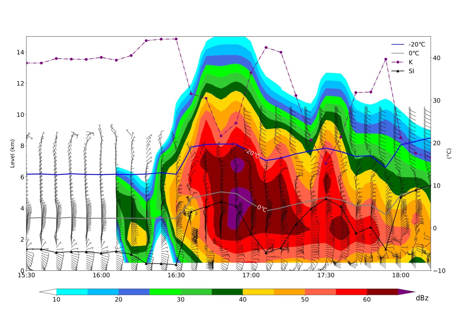
中文摘要: 综合应用多源高频次探测资料,对2020年8月27日北京一次局地突发强对流成因、发展及其在临近预报预警中的可用性进行了分析。研究使用了微波辐射计、风廓线雷达、S波段多普勒雷达、X波段双偏振雷达及三维闪电定位系统等资料,分析了雷暴初生、发展及消亡阶段的演变特征及预警特征。结果表明:微波辐射计反演的温度、湿度及稳定度参数(K指数、SI指数)在强对流发生前30~120 min出现显著变化,有效指示能量积累;风廓线雷达监测的垂直风切变增强和低层暖平流可提前55~120 min反映动力抬升条件;两种雷达通过回波悬垂结构、质心高度变化及双偏振参数(ZDR、KDP)分析冰雹生长区,冰雹及雷暴大风的预警提前量达12~37 min;闪电跃增信号(2σ算法)与强对流天气(冰雹、大风)的对应性显著,首次跃增对冰雹预警的提前量达52 min。2020年其他四次强对流个例验证表明,多源高频次探测资料的协同应用可突破单一设备的观测局限,动态追踪环境能量、风暴结构与闪电活动,为短时临近预报预警提供有利参考。
Abstract:This paper comprehensively uses multi-source high-frequency detection data to analyze the formation causes and development of a localized severe convective event that occurred in Beijing on 27 August 2020, and the applicability of the observation data in nowcasting and warning of such severe convection. Utilizing the data from various high-frequency detection instruments including microwave radiometers, wind profile radars, S-band Doppler radars, X-band dual-polarization radars, and a three-dimensional lightning positioning system, we investigate the evolutionary characteristics and warning indicators during thunderstorm initiation, development and dissipation stages. The results demonstrate that the microwave radiometer-retrieved temperature, humidity and stability parameters (K-index, SI-index) show significant variations 30-120 min prior to the outbreak of severe convection, effectively indicating the energy accumulation. The enhanced vertical wind shear and low-level warm advection detected by wind profile radars can reflect dynamic lifting condition 55-120 min in advance. S/X-band radar observations of echo overhanging structures, centroid height variations, and dual-polarization parameters (ZDR, KDP) enable the identification of hail growth zones, achieving 12-37 min lead time for hail and thunderstorm gale warnings. Lightning jump signals (2σ algorithm) exhibit strong correlation with severe weather (hail and winds), with the first jump providing 52 min lead time for hail warning. Validation of other four severe convective cases in 2020 shows that synergistic application of multi-source observations can overcome the limitation of single-instrument detection, enabling dynamic tracking of environmental energy, storm structure and lightning activities, thereby providing valuable references for short-time forecasting and nowcasting.
文章编号: 中图分类号: 文献标志码:
基金项目:国家自然科学基金项目(42275012、42205091)、中国气象局创新发展专项(CXFZ2023J018)、中国气象局青年创新团队(CMA2023QN10)、北京市科技计划课题(Z221100005222012)、中国气象局创新发展专项(CXFZ2021Z034)、北京市气象局科技项目(BMBKJ202001006)和北京市自然科学基金项目(8244063)共同资助
| 作者 | 单位 |
| 何娜 | 北京市气象台, 北京 100097 |
| 田野 | 北京市气象探测中心, 北京 100089 |
| 陈明轩 | 北京城市气象研究院,北京 100089 |
| 李林 | 北京市气象探测中心, 北京 100089 |
| 杨艺亚 | 北京市气象台, 北京 100097 |
| 韩微 | 北京市气象探测中心, 北京 100089 |
引用文本:
何娜,田野,陈明轩,李林,杨艺亚,韩微,2025.多源高频次探测资料在北京强对流个例临近预报中的应用[J].气象,51(10):1157-1170.
HE Na,TIAN Ye,CHEN Mingxuan,LI Lin,YANG Yiya,HAN Wei,2025.Application of Multi-Source High-Frequency Detection Data to the Nowcasting of Local Severe Convection in Beijing[J].Meteor Mon,51(10):1157-1170.
何娜,田野,陈明轩,李林,杨艺亚,韩微,2025.多源高频次探测资料在北京强对流个例临近预报中的应用[J].气象,51(10):1157-1170.
HE Na,TIAN Ye,CHEN Mingxuan,LI Lin,YANG Yiya,HAN Wei,2025.Application of Multi-Source High-Frequency Detection Data to the Nowcasting of Local Severe Convection in Beijing[J].Meteor Mon,51(10):1157-1170.