本文已被:浏览 493次 下载 2913次
投稿时间:2021-12-18 修订日期:2022-12-08
投稿时间:2021-12-18 修订日期:2022-12-08
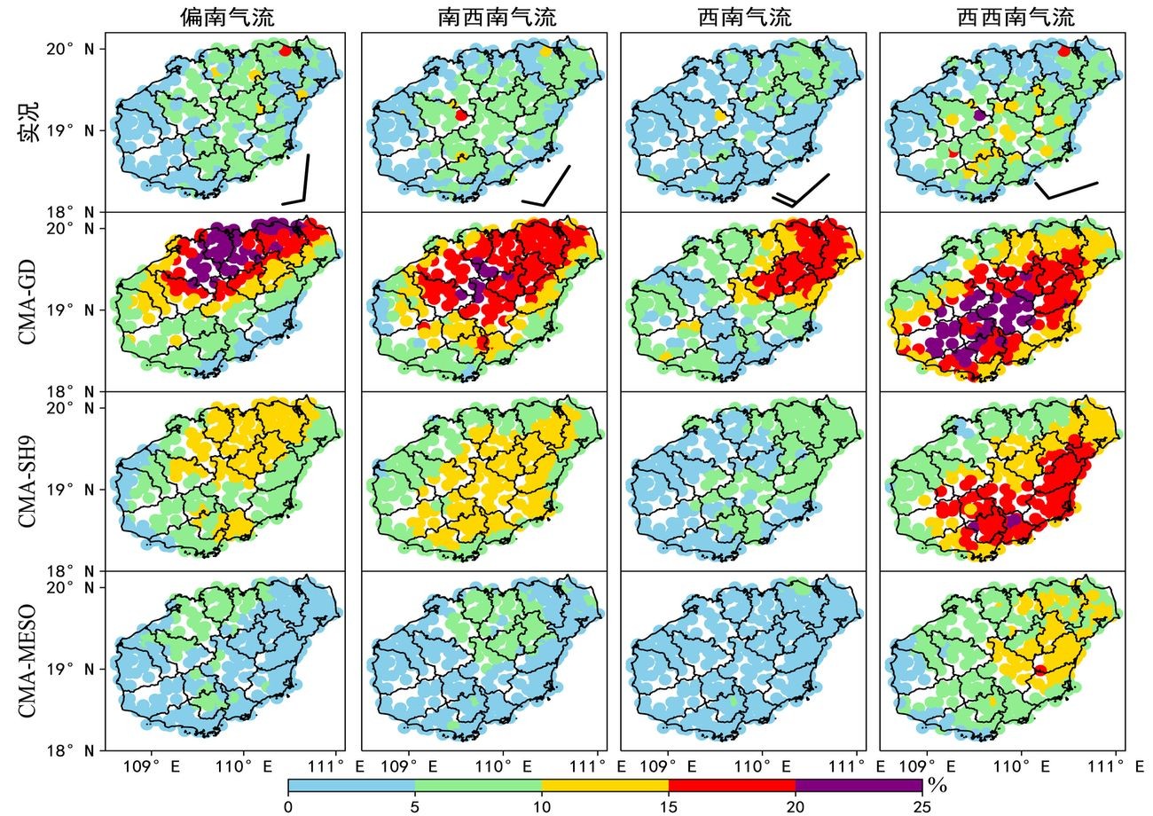
中文摘要: 应用面向降水过程的时空检验方法,评估了中国气象局广东快速更新同化数值预报系统(CMA-GD)、上海数值预报系统(CMA-SH9)和中尺度天气数值预报系统(CMA-MESO)的海南岛暖季(2019—2020年的4—9月)非台风降水日小时降水预报效果,结果表明:三家模式均能捕捉不同流场条件下的降水空间分布形态及降水日变化特征,但CMA-GD和CMA-SH9的降水频率和强度总体偏多偏强,其中CMA-GD降水频率偏多近10%,CMA-SH9平均小时雨强偏强近4 mm·h-1,CMA-MESO雨强在5 mm·h-1以上的降水多分布在西南部和中部山区,与实况空间分布差异较大。三家模式降水预报最易开始和降水峰值时间平均偏早1~3 h,而降水最易结束时间偏晚1~3 h;模式的大气层高层露点温度和不稳定能量预报值偏大,不稳定能量出现时间偏早,近地层逆温层特征预报失真,降水预报的开始时间倾向于提前、降水持续时间偏长。三家模式的昼间海南岛北部沿海的海陆风辐合带预报偏强,其中CMA-SH9尤为明显,与该模式降水强度明显偏强特征相一致;CMA-GD的夜间南部沿海的海陆风辐合带预报位置偏西,与该模式西南部沿海降水频次预报偏多相对应;CMA-MESO的海南岛西南部和中部山区的风速辐合预报偏强,其降水预报强度也相应偏强。
中文关键词: 区域数值模式,海南岛暖季,小时降水,预报偏差
Abstract:Using the spatial-temporal verification method of precipitation process, this paper evaluates the prediction effect of non-typhoon hourly precipitation in warm season (April to September of 2019-2020) of Hainan Island by Guangdong rapid update assimilation numerical prediction system (3 km resolution, CMA-GD), Shanghai numerical prediction system (CMA-SH9) and mesoscale weather numerical prediction system (CMA-MESO) of China Meteorological Administration. 〖JP2〗The results show that the three models 〖JP〗all can capture the spatial distribution of precipitation and the diurnal variation of precipitation under different flow field conditions. However, the frequency and intensity of precipitation in CMA-GD and CMA-SH9 are generally more and stronger, of which the frequency of precipitation in CMA-GD is more than 10%, the average hourly rainfall intensity of CMA-SH9 is nearly 4 mm·h-1 stronger. The precipitation intensity above 5 mm·h-1 of CMA-MESO is mostly distributed in the southwestern and central mountainous areas, which is quite different from the observed spatial distribution. The easiest precipitation start time and precipitation peak time of the three models are 1-3 h earlier than the observation, and the easiest precipita-tion end time is 1-3 h later than the observation; The predicted values of dew point temperature and unstable energy in the upper atmosphere of the model are too large, unstable energy appears earlier, the characteristic prediction of the near-surface inversion layer is distorted, the start time of precipitation forecast tends to be earlier, and the precipitation duration is too long. The sea-land wind convergence zone along the northern coast of Hainan Island is predicted to be strong in the daytime by the three models, especially CMA-SH9, which is consistent with obvious strong precipitation intensity of the model’s output. The forecast position of the sea-land wind convergence zone along the southern coast of CMA-GD at night is westward, which corresponds to the higher frequency of precipitation along the southwestern coast of the model. CMA-MESO has strong wind speed convergence in the southwestern and central mountainous areas of Hainan Island, and the corresponding precipitation forecast intensity is stronger than the observation.
文章编号: 中图分类号: 文献标志码:
基金项目:国家自然科学基金区域创新发展联合基金项目(U21A6001),中国气象局创新发展专项(CXFZ2021Z008)和海南省气象局业务提升项目(hnqxSJ202101)共同资助
引用文本:
吴俞,李玉梅,李勋,冯箫,姜小云,2023.海南岛暖季区域数值模式降水精细化预报检验[J].气象,49(2):235-248.
WU Yu,LI Yumei,LI Xun,FENG Xiao,JIANG Xiaoyun,2023.Verification of Precipitation Refinement Forecast of Regional Numerical Models in the Warm Season of Hainan Island[J].Meteor Mon,49(2):235-248.
吴俞,李玉梅,李勋,冯箫,姜小云,2023.海南岛暖季区域数值模式降水精细化预报检验[J].气象,49(2):235-248.
WU Yu,LI Yumei,LI Xun,FENG Xiao,JIANG Xiaoyun,2023.Verification of Precipitation Refinement Forecast of Regional Numerical Models in the Warm Season of Hainan Island[J].Meteor Mon,49(2):235-248.


