本文已被:浏览 598次 下载 3705次
投稿时间:2021-06-30 修订日期:2022-06-28
投稿时间:2021-06-30 修订日期:2022-06-28
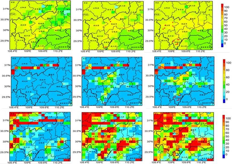
中文摘要: 强降水是滑坡、泥石流等地质灾害的直接诱因,分析其与灾害的发生关系有着重要的意义。从2020年7月鄂西南恩施州连续降雨造成滑坡等地质灾害事件出发,分析了7月的4次强降水过程降水强度与持续时间特征关系,对比了恩施州近年来的地质灾害及致灾背景,并基于区域地质灾害潜在危险性和区域易损性特征,结合5 km空间分辨率、24 h时效多源融合定量降水估测(QPE)驱动陆面水文模型,模拟了灾害过程的径流与土壤湿度特征,着重研究了7月第四次暴雨(7月15—19日)诱发湖北省恩施州8个市(县)群发性滑坡等地质灾害的成因。结果表明,恩施州大部属于地质灾害高易发区,但该区域易损度相对较低,过程降水量100 mm以上,日雨量达到50 mm以上或小时雨量达到10~30 mm,均有可能触发地质灾害,陆面水文过程模拟能较好地表征灾害的发生发展过程,而建立的过程I D曲线对恩施州地区未来的灾害预警有一定的指示作用。
中文关键词: 滑坡,地质灾害,成因分析
Abstract:Geological hazards such as landslides and debris flows are usually caused by severe precipitation directly, so analyzing the correlation between geological hazards and severe precipitation is of great significance. In this paper, four continuous severe rainfall processes in July 2020 responsible for geological disaster events in Enshi Autonomous Prefecture, southwestern Hubei Province are analyzed, the relationships between rainfall intensity and duration are investigated, and the geological disasters and the disaster-caused background in recent years are compared. Based on the potential dangerous 〖JP2〗degree and regional vulnerability 〖JP〗degree of geological disasters and combined with multi-source quantitative precipitation estimation (QPE) with 5 km spatial resolution and 24 h temporal resolution, the land-surface hydrological model is driven to simulate the runoff and soil moisture characteristics during the disaster process. The causes of cluster-occurring geological disasters induced by the fourth rainfall process from 15 to 19 July are emphatically analyzed. The results reveal that most areas of Enshi Autonomous Prefecture are of high potential dangerous degree but have low degree of vulnerability. The rainfall processes with accumulated precipitation over 100 mm, daily accumulated rainfall over 50 mm, or hourly rainfall with 10-30 mm can possibly trigger geological disasters in this region. The land-surface hydrological simulation can better represent the occurrence and development of disasters, while the I-D curve established in this paper can be used as an indicator for early warning in the concerned area.
文章编号: 中图分类号: 文献标志码:
基金项目:国家自然科学基金项目(41871020、41775111、41875131)、国家重点研发计划(2018YFC01508202)、中国气象局气象干部培训学院科研项目(重2021-010)和风云卫星应用先行计划(FY-APP-2021.010)共同资助
引用文本:
狄靖月,许凤雯,李焕连,李宇梅,张国平,陈春利,方志伟,包红军,2022.暴雨诱发恩施州地质灾害成因分析[J].气象,48(10):1321-1332.
DI Jingyue,XU Fengwen,LI Huanlian,LI Yumei,ZHANG Guoping,CHEN Chunli,FANG Zhiwei,BAO Hongjun,2022.Cause of the Geological Hazards Induced by Rainstorm in Enshi Autonomous Prefecture[J].Meteor Mon,48(10):1321-1332.
狄靖月,许凤雯,李焕连,李宇梅,张国平,陈春利,方志伟,包红军,2022.暴雨诱发恩施州地质灾害成因分析[J].气象,48(10):1321-1332.
DI Jingyue,XU Fengwen,LI Huanlian,LI Yumei,ZHANG Guoping,CHEN Chunli,FANG Zhiwei,BAO Hongjun,2022.Cause of the Geological Hazards Induced by Rainstorm in Enshi Autonomous Prefecture[J].Meteor Mon,48(10):1321-1332.