本文已被:浏览 557次 下载 3000次
投稿时间:2021-08-26 修订日期:2022-03-11
投稿时间:2021-08-26 修订日期:2022-03-11
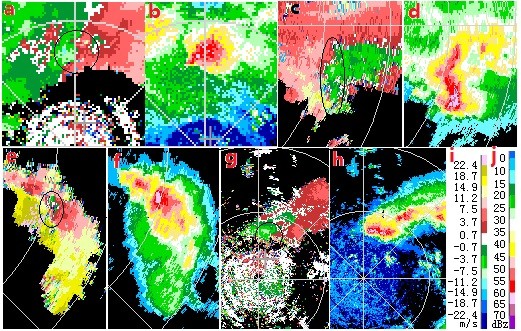
中文摘要: 利用探空资料、CIND3830 CC天气雷达和地面观测资料,以2013—2020年云南普洱市21次冰雹天气过程为样本,将冰雹直径≥20 mm的风暴单体定义为大冰雹风暴单体,5 mm≤直径<20 mm的风暴单体定义为中冰雹风暴单体,直径<5 mm的风暴单体定义为小冰雹风暴单体(GB/T27957—2011),对比分析小冰雹、中冰雹、大冰雹风暴单体的多普勒雷达回波特征。结果表明:冰雹风暴单体的共同特征是:高顶高底结构、风暴的高质心伸展高度≥5 km、回波梯度较大、组合反射率CR≥55 dBz、〖JP〗垂直液态水含量VIL≥23 kg·m-2、45 dBz顶高H45 dBz≥7.5 km、H45 dBz-H0℃≥2.8 km。67%的冰雹风暴单体在降雹前5~10 min 出现VIL跃增现象,跃增幅度越大,相应VIL越大。冰雹风暴单体均存在明显的辐合特征,大冰雹风暴单体往往具有中气旋特征。大冰雹风暴单体的VIL/H、H50 dBz-H-20℃和成熟阶段持续时间均显著大于中、小冰雹风暴单体的相同指标。大冰雹风暴单体的回波悬垂结构、DVIL(VIL/ET)和旋转速度往往多(大)于中、小冰雹风暴单体的相同指标。回波顶高(ET)、VIL跃增特征、TBSS和V形缺口都不能作为识别不同等级冰雹的指标。
中文关键词: 冰雹等级,预报,回波特征,径向速度,垂直剖面
Abstract:Based on the air-sounding data, the CIND3830-CC CINRAD data and surface meteorological data, and 21 hail weather processes in Pu’er during 2013-2020, this study gives the difinition to storm cells with hail diameter ≥20 mm as large hail storm cells, storm cells with hail diameter ≥5 mm and less than 20 mm as medium hail storm cells and storm cells with hail diameter <5 mm as small hail storm 〖JP2〗cells (GB/T27957-2011). The Doppler radar echo characteristics of small hail, mdium hail and large hail are comparatively analyzed. The results show that hail storm cells have common characteristics. High top and high bottom structure of the radar echo, height above 5 km and large echo gradient and composite reflectivity (CR)≥55 dBz、VIL≥23 kg·m-2、H45 dBz≥7.5 km、H45 dBz-H0℃≥2.8 km. VIL shows jump phenomenon in 67% hail storm cells, appearing 5-10 min before the occurrence of hail falls. The bigger the magnitude of the jump, the greater the corresponding VIL. The hail storm cells have obvious convergence characteristics and large hailstorm cells often have mesocyclone characteristics. All the large hail storm cells are significantly greater than the medium and small hail storm cells in VIL/H. H50 dBz-H-20℃ of most large hail storm cells are significantly greater than those of medium and small hail storm cells. Large hail storm cells in mature stage often lasts significantly longer than medium and small hail storm cells. The echo overhang structure of large hail storm cells is often more than the medium and small hail storm cells, and DVIL and the rotation speed are often greater than medium and small hail storm cells. ET, VIL jump characteristics, TBSS and V-notch can not be used as indicators to identify different grades of hails.
文章编号: 中图分类号: 文献标志码:
基金项目:国家重点研发计划(2018YFC1507503)、国家自然科学基金项目(41075072)共同资助
| 作者 | 单位 |
| 王晓君 | 云南省普洱市气象局,普洱 665000 |
| 郑媛媛 | 中国气象局交通气象重点开放实验室,南京 210041 江苏省气象科学研究所,南京 210041 南京气象科技创新研究院,南京 210041 |
引用文本:
王晓君,郑媛媛,2022.普洱市不同等级冰雹天气的雷达回波特征对比分析[J].气象,48(7):868-877.
WANG Xiaojun,ZHENG Yuanyuan,2022.Comparative Analysis of Radar Echo Characteristics of Different Grades of Hail Weather in Pu’er[J].Meteor Mon,48(7):868-877.
王晓君,郑媛媛,2022.普洱市不同等级冰雹天气的雷达回波特征对比分析[J].气象,48(7):868-877.
WANG Xiaojun,ZHENG Yuanyuan,2022.Comparative Analysis of Radar Echo Characteristics of Different Grades of Hail Weather in Pu’er[J].Meteor Mon,48(7):868-877.