本文已被:浏览 659次 下载 3668次
投稿时间:2020-04-03 修订日期:2021-06-18
投稿时间:2020-04-03 修订日期:2021-06-18
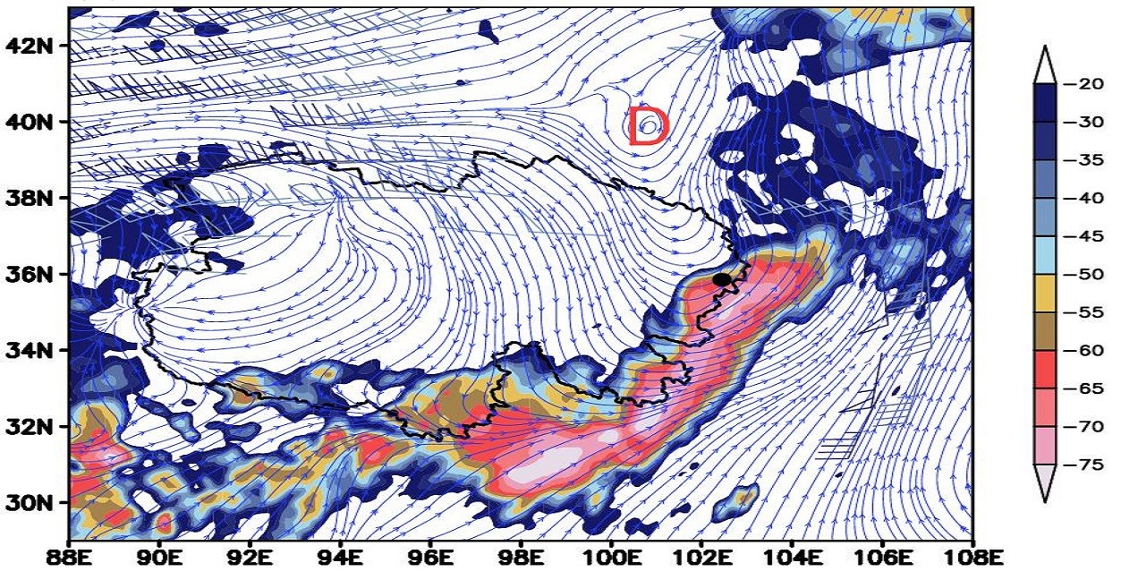
中文摘要: 利用2018—2020近三年青海河湟谷地低涡切变影响下强降水天气个例地面观测、NCEP 1°×1°再分析、FY-2G云图相当黑体亮温温度、模式及雷达拼图等资料,对比分析相同环流背景影响下不同类型强降水环境条件和成因差异,以及初步评估模式预报能力。结果表明:伴有雷暴、冰雹、雷暴大风等混合性强降水天气称为强降水Ⅰ型,以纯短时强降水为主的强降水天气称为强降水Ⅱ型。低涡切变是两种类型强降水的影响系统,强降水Ⅰ型400~300 hPa高空冷平流入侵促使低涡切变系统加强东移,地面冷锋发展在河湟谷地形成锢囚锋。强降水Ⅱ型受副热带高压西进阻挡,低涡切变系统和地面冷锋减弱消失;强降水Ⅰ型主要具有较强的高空干冷急流、高的下沉对流有效位能,较高的700 hPa和400 hPa温差以及强的垂直风切变均为强对流发生提供动力条件,产生的强天气以风雹类为主,而强降水Ⅱ型具有较高的0℃层和-20℃层高度、较高的抬升凝结高度,产生的强天气以短时强降水为主;强降水Ⅰ型云图特征主要表现为午后发展起来组织化程度高的冷涡云系,相当黑体亮温(TBB)初始中心数值在-45~-35℃,发展阶段TBB下降至-75~-40℃,强降水Ⅱ型云图特征主要表现为分散的块状对流云系,TBB初始中心数值在-35℃左右,发展阶段TBB下降至-70~-50℃;地面辐合线是两类强降水的触发系统,强降水Ⅱ型假相当位温数值大于强降水Ⅰ型,以热力强迫为主,强降水Ⅰ型垂直速度大于强降水Ⅱ型,以动力强迫为主;全球同化预报系统相比中尺度天气数值预报系统更具优势,ECMWF和CMA-MESO两种模式对500 hPa低涡切变有较好的刻画,ECMWF模式能较好模拟出对流有效位能,三家模式降水量级预报明显偏大、降水中心位置偏北偏西,而中国气象局中尺度天气数值预报系统CMA-MESO模式在降水预报方面略具有优势。
中文关键词: 河湟谷地,低涡切变,短时强降水,环境条件,成因对比
Abstract:Based on the ground observation, NCEP 1°×1° reanalysis, FY-2G TBB, model data and radar mosic data of two type severe precipitations under the influence of low vortex shear in the Qinghai Hehuang Valley in the past three years, the comparative analysis is conducted about the environmental conditions and causes of different types of severe precipitation under the influence of the same circulation background, and also about the preliminary assessment of the model’s forecasting capabilities. The results show that the mixed severe precipitation weather with thunderstorm, hail, thunderstorm and gale is called severe precipitation type Ⅰ, and the severe precipitation weather dominated by pure short-term severe precipitation is called severe precipitation type Ⅱ. The low vortex shear was the impact system of the two types of severe precipitation. The severe precipitation type Ⅰ 400-300 hPa high-altitude cold advection intrusion promoted the eastward movement of the low vortex shear system, and the development of the ground cold front formed an occluded front in the Hehuang Valley. The severe precipitation type Ⅱ was blocked by the westward advance of the subtropical high, and the low vortex shear system and the ground cold front weakened and disappeared. Severe precipitation type I mainly had strong high-altitude dry-cold jets, high sinking convective effective potential energy, high temperature difference between 700 hPa and 400 hPa, and strong vertical wind shear all provided power conditions for the occurrence of severe convection, and the severe weather produced was mainly gale and hail. The severe precipitation type Ⅱ had a higher height of 0℃ layer and -20℃ layer, a higher uplift and condensation height, and the severe weather produced was dominated by short-term severe precipitation. The characteristics of the severe precipitation type Ⅰ cloud map were mainly manifested in the cold vortex cloud system with a high degree of organization developed in the afternoon.The initial center value of TBB was between -45℃ and -35℃, and the TBB dropped to -75℃ to -40℃ in the developing stage. In the meantime, the type Ⅱ cloud image of severe precipitation was mainly characterized by scattered massive convective cloud system. The initial center value of TBB was around -35℃, and TBB dropped to -70℃ to -50℃ in the developing stage. Ground convergence lines were two types of severe precipitation trigger systems.The pseudo-equivalent potential temperature value of the severe precipitation type Ⅱ was greater than that of the severe precipitation type Ⅰ, and was dominated by thermal forcing.The vertical velocity of the severe precipitation type Ⅰ was greater than that of the severe precipitation type Ⅱ, which was dominated by dynamic forcing. The global model assimilation forecasst system had more advantages than the mesoscale weather numerical forecast system. The two models of ECMWF and CMA-MESO could better characterize the 500 hPa low vortex shear. The ECMWF model could better simulate the effective convective potential energy, and the three models could predict precipitation magnitude obviously larger and the center of precipitation was more northward and westward, and the mesoscale weather numerical forecast system of China Meteorological Administration CMA-MESO had a slight advantage in precipitation forecasting.
文章编号: 中图分类号: 文献标志码:
基金项目:国家自然科学基金项目(91337109)、青海省科技厅基础研究计划项目(2021-ZJ-753)、青海省气象台强天气预报预警创新团队、高原与盆地暴雨旱涝灾害四川省重点实验室开放研究基金项目(SZKT202109)和公益性行业(气象)科研专项(GYHY201306006)共同资助
| 作者 | 单位 |
| 苏永玲 | 青海省气象台,西宁 810001 高原与盆地暴雨旱涝灾害四川省重点实验室,成都 610072 |
| 李生辰 | 青海省气象科学研究所,西宁 810001 |
| 胡垚 | 青海省气象台,西宁 810001 |
| 张雪琦 | 青海省气象台,西宁 810001 |
| 梅成红 | 青海省气象台,西宁 810001 |
引用文本:
苏永玲,李生辰,胡垚,张雪琦,梅成红,2022.低涡切变影响下河湟谷地两类强降水环境条件及成因对比[J].气象,48(1):44-60.
SU Yongling,LI Shengchen,HU Yao,ZHANG Xueqi,MEI Chenghong,2022.Comparison of Environmental Conditions and Causes of Two Types of Severe Precipitation Affected by Low Vortex Shear in Hehuang Valley[J].Meteor Mon,48(1):44-60.
苏永玲,李生辰,胡垚,张雪琦,梅成红,2022.低涡切变影响下河湟谷地两类强降水环境条件及成因对比[J].气象,48(1):44-60.
SU Yongling,LI Shengchen,HU Yao,ZHANG Xueqi,MEI Chenghong,2022.Comparison of Environmental Conditions and Causes of Two Types of Severe Precipitation Affected by Low Vortex Shear in Hehuang Valley[J].Meteor Mon,48(1):44-60.