本文已被:浏览 731次 下载 3670次
投稿时间:2020-01-23 修订日期:2021-03-17
投稿时间:2020-01-23 修订日期:2021-03-17
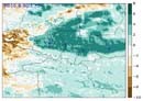
中文摘要: 利用FY-4A多通道扫描成像辐射计(AGRI)所生成的多通道图像及L2级卫星云产品数据,结合地面观测实况资料,对2019年1月25—26日和3月17—18日发生于乌鲁木齐国际机场的两次持续性浓雾天气进行分析,结果表明:对于浓雾的监测,白天综合使用通道3(BD0.83 μm)、通道6(BD2.2 μm)、通道8(BD3.725 μm)和通道12(BD10.8 μm)能很好地显示雾区范围、雾顶云结构、雾区温度等特征,且云图能很好地表现雾的消散。夜间可以结合BD10.8 μm和BD3.725 μm的差(以下简写为BTD10.8 μm-3.725 μm)和BD10.8 μm图像,用于识别夜间雾区,BTD10.8 μm-3.725 μm通道亮温差越大说明雾的浓度越强。FY-4A卫星云顶高度和云分类产品对雾〖JP2〗的微物理特征结构反应更为细致,对于夜间大雾监测有较好的效果,能够弥补可见光通道1~通道3、〖JP〗短波红外通道(BD2.2 μm)和中波红外通道(BD3.725 μm)仅能在白天使用的不足。
Abstract:Using FY-4A images generated by advanced geosynchronous radiation imager (ARGI) and level 2 satellite cloud product data and surface observation data, this paper analyzes two dense fog weather events that happened in 25-26 January 2019 and in 17-18 March 2019 at Urumqi International Airport. The results show that we can use Channel 3 (BD0.83 μm), Channel 6 (BD2.2 μm) Channel 8 (BD3.725 μm) and Channel 12 (BD10.8 μm) to monitoring the range of dense fog and the cloud structure features of fog top and the temperature of fog area during the daytime. Dissipation of fog has a good reflection on satellite images. At night, the difference between BD10.8 μm and BD3.725 μm (BTD10.8 μm-3.725 μm) and images of BD10.8 μm can be combined to identify the night foggy area, and the greater the bright temperature difference in the BTD10.8 μm-3.725 μm channels, the denser the fog. FY-4A satellite cloud top height and cloud classification products have more meticulous features on microphysical characteristics of dense fog. It is very effective in monitoring night dense fog and it also can make up for the deficiency of visible channels such as from Channel 1 to Channel 3, Channel 6 and Channel 8, which can only be used in the daytime.
keywords: FY-4A, cloud phase, cloud type, cloud top height, advanced geosynchronous radiation imager(AGRI)
文章编号: 中图分类号: 文献标志码:
基金项目:新疆维吾尔自治区自然科学基金面上项目(2020D01A99)和国家重点研发计划(2018YFC1507103)共同资助
引用文本:
王清平,朱雯娜,王勇,陈阳权,韩磊,王春红,谭艳梅,张利平,2021.FY-4A资料在乌鲁木齐机场浓雾天气监测中的初步应用[J].气象,47(5):627-637.
WANG Qingping,ZHU Wenna,WANG Yong,CHEN Yangquan,HAN Lei,WANG Chunhong,TAN Yanmei,ZHANG Liping,2021.Preliminary Application of FY-4A Satellite Data in Dense Fog Weather Events at Urumqi International Airport[J].Meteor Mon,47(5):627-637.