本文已被:浏览 1645次 下载 4417次
投稿时间:2020-04-05 修订日期:2020-12-07
投稿时间:2020-04-05 修订日期:2020-12-07
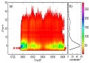
中文摘要: 利用地面自动站观测、风廓线雷达、ERA5再分析资料、葵花8号高分辨率卫星资料以及FM 120型雾滴谱资料,分析了2019年4月7日闽南沿海一次强浓雾过程的环流形势以及微物理特征。环流形势分析表明,此次海雾过程500 hPa为槽底偏西西北气流,700 hPa至地面为一致的偏南气流,探空形势稳定。海雾发生前,整层风速明显减小,弱风速层厚度迅速增大,为海雾的形成提供了稳定的环流背景。卫星监测分析表明,海雾首先快速形成于台湾海峡上,在偏南气流作用下,平流至沿海地区。水文条件分析表明,福建近海存在一条冷水带,从海峡中部至沿海海温梯度大,海温在18~24 ℃,近海气海温差介于0~2 ℃,有利于海峡内平流冷却雾的形成。雾滴谱分析表明,翔安站能见度显著下降伴随着粒子数浓度、液态水含量显著增加,雾滴谱爆发性拓宽。海雾过程中,5 min平均粒子数浓度最大超过200个·cm-3,瞬时数浓度最大达到468个·cm-3,雾过程平均数浓度为100 个·cm-3。5 min平均液态水含量最高达到0.41 g·m-3,瞬时液态水含量最大达到1.35 g·m-3,雾过程平均液态水含量为0.17 g·m-3。粒子浓度呈现双峰结构特征,峰值分别位于4~6和22~26 μm,表明小粒子和大粒子对海雾的形成均有明显的贡献。
中文关键词: 海雾,气海温差,雾滴谱
Abstract:Based on the data of automatic weather station, wind profiling radar, ERA5 reanalysis, Himawari 8 high resolution satellite and FM 120 fog droplet spectrometer, we discuss the circulation pattern and microphysical characteristics of an sea fog event that happened in southern coastal area of Fujian Province on 7 April 2019. Circulation analysis shows that this sea fog event occurred under the control of west to northwest flow at 500 hPa trough bottom, while from 700 hPa to surface there was uniform southerly flow. The sounding situation was stable. Before sea fog event, low level wind speed decreased significantly, increasing the thickness of low wind speed. This situation provided stable circulation for sea fog. Himawari 8 satellite images show that the sea fog rapidly formed in the Taiwan Strait first and then advected to coastal area affected by low level southerly airflow. Hydrological analysis indicates that there existed a cold water band and large temperature gradient near the shore. Sea surface temperature (SST) varied between 18 ℃ and 24 ℃. The air and sea temperature difference was between 0 ℃-2 ℃ with sea surface colder than the air above, which contributed to the formation of advective sea fog. Fog droplet spectrum analysis shows that visibility decreased dramatically while particle number concentration (PNC), liquid water content (LWC) and droplet spectrum increased significantly at the same time. During the sea fog process, 5 min average PNC exceeded 200 cm-3 and instantaneously reached 468 cm-3 maximum, and the average PNC during the fog process reached 100 cm-3. The 5 min average LWC reached 0.41 g·m-3 and 1.35 g·m-3 instantaneously. The average LWC during the fog process reached 0.17 g·m-3. Fog droplet size featured double peaks with 4-6 μm and 22-26 μm intervals respectively during the fog process. This indicates that small and big particles both can contribute to the formation of sea fog.
文章编号: 中图分类号:P426,P445 文献标志码:
基金项目:国家自然科学基金项目(41705045)和厦门市气象局海洋气象创新团队共同资助
引用文本:
张伟,陈德花,胡雅君,荀爱萍,蒋永成,孙学金,2021.闽南沿海一次春季海雾过程微物理特征分析[J].气象,47(2):157-169.
ZHANG Wei,CHEN Dehua,HU Yajun,XUN Aiping,JIANG Yongcheng,SUN Xuejin,2021.Microphysical Structure Analysis of a Spring Sea Fog Event in Southern Coastal Area of Fujian[J].Meteor Mon,47(2):157-169.
张伟,陈德花,胡雅君,荀爱萍,蒋永成,孙学金,2021.闽南沿海一次春季海雾过程微物理特征分析[J].气象,47(2):157-169.
ZHANG Wei,CHEN Dehua,HU Yajun,XUN Aiping,JIANG Yongcheng,SUN Xuejin,2021.Microphysical Structure Analysis of a Spring Sea Fog Event in Southern Coastal Area of Fujian[J].Meteor Mon,47(2):157-169.