本文已被:浏览 1347次 下载 5859次
投稿时间:2020-08-08 修订日期:2020-10-01
投稿时间:2020-08-08 修订日期:2020-10-01
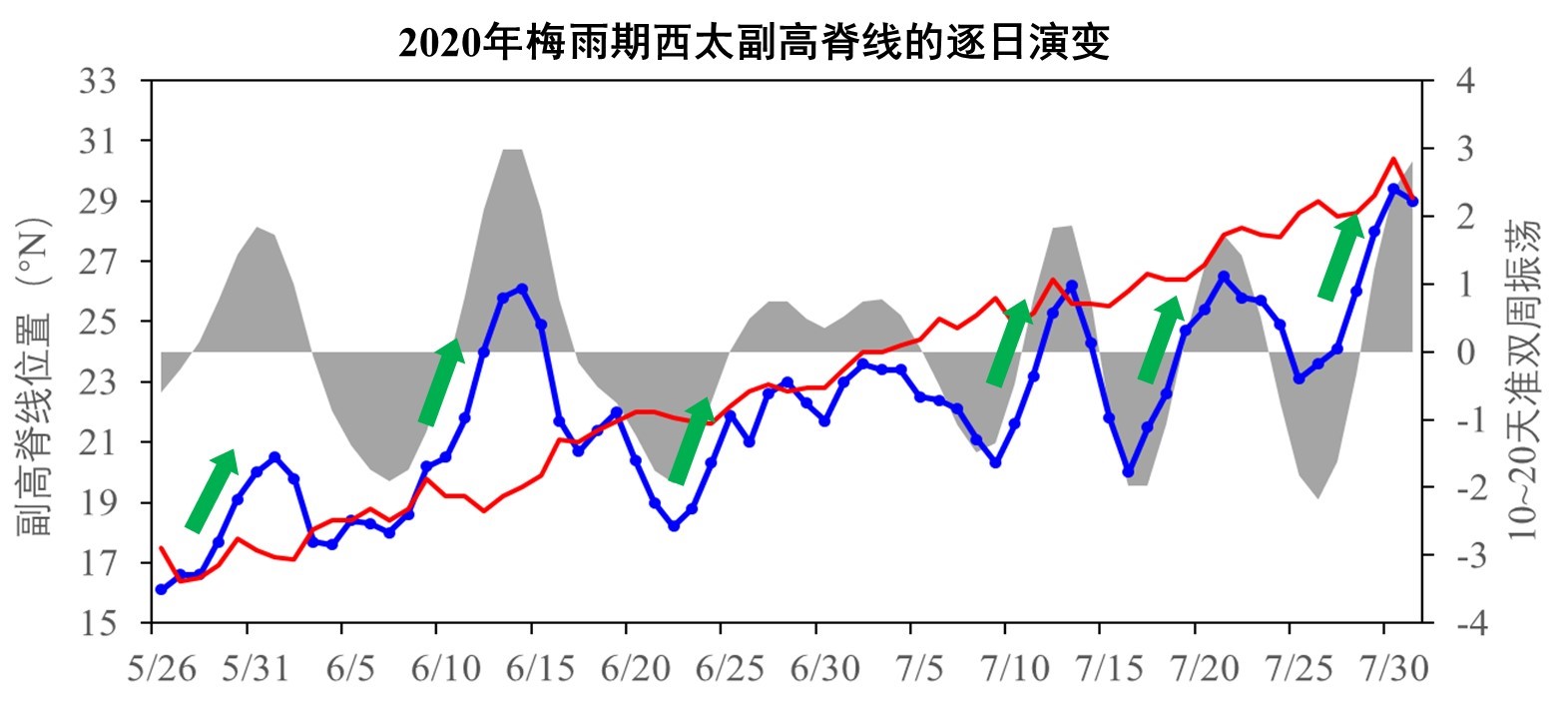
中文摘要: 2020年梅雨呈现出入梅早、出梅晚、梅雨期长、雨区范围广、累计雨量大、强降水过程多的特点,是一次典型的超强梅雨。分析发现,梅雨期东亚季风区多个关键大气环流系统的平均位置相对稳定,且表现出显著的准双周振荡特征。梅雨的开始和结束、主雨带的北抬和停滞、强降水过程的发生维持都与准双周振荡有很好的对应关系。梅雨期间西太平洋副热带高压共经历了6次北抬和南撤的周期性振荡,同时高、低层季风环流系统则表现出5次显著增强的过程,尤其是低空西南急流的不断加强,南风大值中心反复建立和位置的相对稳定,使得源自热带的水汽输送一次次加强,水汽辐合与上升运动反复发展,从而导致梅雨在江淮流域长时间持续,暴雨过程频频发生。另外,梅雨期欧亚中高纬环流表现为“两脊一槽”型,中高纬阻塞高压活动频繁,东亚沿岸低槽活跃,经西北路径和(或)东北路径的冷空气不断南下,与低层一次次加强的西南暖湿水汽在江淮区域频繁交汇,这是造成今年梅雨异常偏强的另一重要因素。通过对历史上梅雨的时空分布、雨涝特征及致灾程度等方面的比较可知,2020年的超强梅雨的异常程度总体弱于1954年,而强于1998年和1991年。得益于现今气候预测准确率和防灾减灾能力的明显提高,今年由此次超强梅雨而造成的江淮流域洪涝灾害影响及死亡失踪人数等均较之前明显降低。
Abstract:The extreme Meiyu in 2020 was featured with earlier onset, later retreat, longer duration of rainy season, wider rainfall range, abundant accumulated rainfall, and more severe rainfall processes than normal. Through the analysis of simultaneous atmospheric circulation systems, we have found that the average locations of the key East Asian monsoon circulation systems were relatively stable, with significant characteristic of quasi-biweekly oscillation (QBWO) in the Meiyu season of 2020. The onset and retreat of Meiyu, the northward shift and stagnation of the rainfall belt, and the occurrence and persistence of severe rainstorm processes had a good relationship with the QBWO. During the Meiyu season, the western Pacific subtropical high experienced six periodic oscillations of northward migration and southward retreat. Meanwhile, the upper- and low-level monsoon circulation systems strengthened for five times corresponding with the QBWO in the Meiyu season. Especially, the strengthening of the southwesterly low-level jet, add the repeated establishment of the large-value centers of southerly with relatively consistent latitude made the water vapor transport from the tropics strengthened again and again, and the water vapor convergence and upward movement developed repeatedly, leading to the long-term persistence of Meiyu in the Yangtze-Huaihe River Valley (YHRV) and frequent occurrences of rainstorms. On the other hand, two blocking highs maintained in the mid- and high latitudes, which was characterized by the spatial pattern of “two ridges and one trough” over Eurasia, and the low trough along the East Asian coast was also active. The cold air flew continuously southward through the northwestern and/or northeastern paths, frequently merging with the repeatedly strengthened warm moisture from the low latitude over the YHRV. So, this is another important factor causing the extreme Meiyu in 2020. Moreover, by comparing the spatio-temporal distribution of Meiyu and the corresponding flood disaster in 2020 with other super Meiyu years since 1951, we have also found that the Meiyu in 2020 was weaker than that of 1954, but stronger than that of 1998 and 1991. Thanks to the improvement of both the accuracy of climate prediction and the ability of disaster prevention and mitigation, the flood and disaster losses caused by the 2020 extreme Meiyu in the YHRV were significantly less than before.
文章编号: 中图分类号: 文献标志码:
基金项目:国家重点研发计划(2018YFC1505806)、第二次青藏高原综合科学考察研究(2019QZKK0208)、中国科学院战略性先导科技专项(XDA20100304)、国家自然科学基金项目(41790471)和中国气象局预报员专项(CMAYBY2020-164)共同资助
引用文本:
刘芸芸,丁一汇,2020.2020年超强梅雨特征及其成因分析[J].气象,46(11):1393-1404.
LIU Yunyun,DING Yihui,2020.Characteristics and Possible Causes for the Extreme Meiyu in 2020[J].Meteor Mon,46(11):1393-1404.
刘芸芸,丁一汇,2020.2020年超强梅雨特征及其成因分析[J].气象,46(11):1393-1404.
LIU Yunyun,DING Yihui,2020.Characteristics and Possible Causes for the Extreme Meiyu in 2020[J].Meteor Mon,46(11):1393-1404.