本文已被:浏览 892次 下载 4095次
投稿时间:2019-05-17 修订日期:2020-03-04
投稿时间:2019-05-17 修订日期:2020-03-04
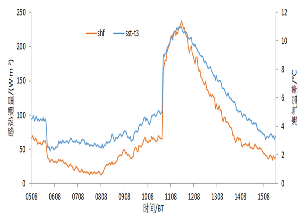
中文摘要: 利用海上浮标站、自动站、多普勒天气雷达、L波段雷达探空、NCEP/NCAR再分析逐6 h和降水等观测资料,结合EVAP雷达风场反演获得的水平风场资料,对2018年1月9—11日一次渤海海效应暴雪过程的产生机制进行了分析。结果表明:此次海效应暴雪过程是一次极端降雪事件,具有强降雪持续时间长、降雪量大、暴雪分布近γ中尺度等特征。暴雪发生前后受两次强冷空气影响,渤海和山东半岛地区持续降温,850 hPa温度降至-18~-16℃,是产生强海效应降雪的有利条件;此次冷空气明显强于12月渤海海效应暴雪,1月产生海效应暴雪的850 hPa温度中位数较12月低约5℃。受强冷空气影响时,海气温差明显增大,海洋向低层大气输送的最大感热通量可达226.8 W·m-2,低层大气高湿饱和,导致大气层结不稳定,不稳定局限于850 hPa以下,为浅层对流。雷达反射率因子图上具有明显的“列车效应”。造成窄带回波的原因在于出现了低层切变线,即在山东半岛北部沿海的小范围区域内出现了东北风及西西南风,形成了西北风与东北风、西西南风与东北风的切变线,触发暴雪产生。而东北风达到的高度不超过1.2 km,多在0.6 km以下。通过此次极端暴雪过程的综合观测资料分析,揭示了较少出现的1月海效应暴雪的特征,其形成的环流形势、热力不稳定、动力条件等与常见的12月海效应暴雪基本类似,主要差异在于冷空气强度较12月偏强,这可成为1月海效应暴雪的首要预报着眼点;海上浮标站、雷达风场反演技术是定量揭示海效应暴雪中尺度特征的良好资料和方法。
中文关键词: 海效应暴雪,产生机制,强冷空气,反演风场
Abstract:Analysis is conducted on the generation mechanism of ocean-effect snowstorm in Bohai which occurred from 9 to 11 January 2018, based on multiple observation data of buoy station, automatic weather station, Doppler weather radar, L-band radar, NCEP/NCAR 6 h reanalysis and precipitation, combined with horizontal wind data retrieved from EVAP technology. The results are as follows: This ocean-effect snowstorm process was an extreme snowfall event, characterized by long duration of heavy snowfall, large snowfall amount and near meso-γ scale distribution of snowstorm. The temperature of Bohai Sea and Shandong Peninsula decreased continuously caused by two strong cold air effect before and after the snowstorm. The 850 hPa temperature dropped to -18 to -16℃, which was helpful to the strong ocean-effect snowstorm generation. The cold air strength of this process was obviously stronger than December ocean-effect snowstorm. It was found that the median cold air strength of January ocean-effect snowstorm was about 5℃ lower than in December. Obvious difference of air and SST led to prominent sense heat flux with maximum 226.8 W·m-2 when strong cold air was active, and convective instability occurred over Bohai Sea and the coastal areas of northern Shandong Peninsula. It was a thin convection limited below 850 hPa. There was an obvious thermal ridge of pseudo-equivalent potential temperature during the snowstorm. The radar reflectivity factor graphs show up the obvious “train effect”. NE and WSW winds appeared over a small coastal area of northern Shandong Peninsula, causing wind direction shear lines of NW and NE, WSW and NE. The lower shear line led to the narrow-band echo which triggered the snowstorm. And the NE wind reached the height of less than 1.2 km, mostly under 0.6 km. Characteristics of the January ocean-effect snowstorm that less appeared are revealed though the study of this extreme snowstorm process. Its characteristics such as the circulation pattern, thermal instability and dynamical condition are similar to those of the December ocean-effect snowstorm. The major difference is that the cold air strength is stronger than in December, which could be the primary forecasting focus of January ocean-effect snowstorm. Buoy data and EVAP radar retrieved wind can quantitatively reflect the mesoscale feature of ocean-effect snowstorm.
文章编号: 中图分类号: 文献标志码:
基金项目:国家自然科学基金面上项目(41475038)和中国气象局预报员专项(CMAYBY2018-042)共同资助
引用文本:
李刚,刘畅,曹玥瑶,孟宪贵,2020.一次1月山东半岛东部极端海效应暴雪的发生机制分析[J].气象,46(8):1074-1088.
LI Gang,LIU Chang,CAO Yueyao,MENG Xiangui,2020.Case Study on Generation Mechanism of Extreme Ocean-Effect Snowstorm in the East of Shandong Peninsula in January[J].Meteor Mon,46(8):1074-1088.
李刚,刘畅,曹玥瑶,孟宪贵,2020.一次1月山东半岛东部极端海效应暴雪的发生机制分析[J].气象,46(8):1074-1088.
LI Gang,LIU Chang,CAO Yueyao,MENG Xiangui,2020.Case Study on Generation Mechanism of Extreme Ocean-Effect Snowstorm in the East of Shandong Peninsula in January[J].Meteor Mon,46(8):1074-1088.