本文已被:浏览 2043次 下载 4904次
投稿时间:2019-11-22 修订日期:2019-12-20
投稿时间:2019-11-22 修订日期:2019-12-20
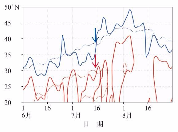
中文摘要: 为更好了解2019年夏季(6—8月)我国主要气候异常特征及成因,利用气象要素站点资料和NCEP/NCAR再分析大气环流资料分析了2019年夏季降水、气温的时空分布和东亚大气环流特征,并初步诊断了长江中下游降水偏少的可能原因。结果显示,2019年夏季全国气温偏暖明显,降水总量接近常年,但旱涝分布有明显的空间差异,东部主要多雨区位于江南至华南及东北地区,云南和黄淮等地气象干旱长时间持续。东部季风区降水还呈现出明显的季节内变化,尤其是江南等地在夏季前期降水过程密集,涝灾严重,但后期急速减少,高温事件迅速爆发。华南前汛期和江南梅雨开始早结束晚。2019年夏季,欧亚中高纬度地区两槽一脊的环流形势非常明显。其中黄海至日本海持续维持的低槽造成夏季西太平洋副热带高压强度偏强,位置略偏西偏南。这一低槽也是长江中下游少雨和江南多雨的直接原因。其在夏季前期位置明显偏南,和副热带高压脊线南北位置的演变非常一致。但在夏季后期,随着这一低槽的减弱北移,副热带高压迅速北跳,也造成雨带从江南快速移动到北方地区。
中文关键词: 夏季降水,梅雨,东亚夏季风指数,西太平洋副热带高压
Abstract:To better understand the basic features and causes of the climate anomalies in summer 2019 (June-July-August 2019) in China, this paper analyzes the spatio-temporal distributions of the precipitation and temperature in the period, as well as the features of the general circulation in East Asia on the basis of the observation data and the NECP/NCAR reanalysis data. The possible reason why less precipitation occurred in the middle and lower reaches of the Yangtze River under an El Ni〖AKn~D〗o event is also diagnosed preliminarily. The results illustrate that in the summer of 2019, the temperature was warmer than normal in most regions in China, and the national averaged precipitation was close to normal, but the distribution of droughts and floods had obvious spatial differences. The main rainfall centers in eastern China were located from the regions south of the Yangtze River (Jiangnan) to South China and in Northeast China, while persistent meteorological droughts occurred in Yunnan Province and the Huanghuai Region. The precipitation in eastern China also showed remarkable intraseasonal variation, especially in the Jiangnan Region. In early summer, the precipitation in Jiangnan occurred in a high frequency, causing serious floods. In late summer, the precipitation decreased rapidly but high temperature developed rapidly. The pre-flood season in South China and the Chinese Meiyu season in the south of the Yangtze River both began earlier and ended late. In the summer of 2019, the atmospheric circulation in Eurasian Continent presented a typical negative-positive-negative pattern. The sustained trough over the Yellow Sea of China and the Japan Sea resulted in a more southward and westward western Pacific subtropical high (WPSH). This trough was also the direct cause for the less rainfall in the middle and lower reaches of the Yangtze River and more rainfall in the south of the Yangtze River. It was obviously by south in the early summer, which is consistent with the evolution of the WPSH. However in the late summer, the trough weakened and moved northward, and the WPSH traveled northward rapidly, which led the rain belt to move rapidly to northern China.
keywords: summer precipitation, Meiyu, East Asian summer monsoon, western Pacific subtropical high (WPSH)
文章编号: 中图分类号: 文献标志码:
基金项目:国家重点研发计划(2018YFC1505603)、公益性行业(气象)科研专项(GYHY201306033)和中国气象局预报员专项(CMAYBY2019-149)共同资助
| Author Name | Affiliation |
| DING Ting | National Climate Centre, Beijing 100081 |
| GAO Hui | National Climate Centre, Beijing 100081 |
引用文本:
丁婷,高辉,2020.2019年夏季东亚大气环流异常及对我国气候的影响[J].气象,46(1):129-137.
DING Ting,GAO Hui,2020.Atmospheric Circulation in East Asia in Summer 2019 and Its Influence on Climate of China[J].Meteor Mon,46(1):129-137.
丁婷,高辉,2020.2019年夏季东亚大气环流异常及对我国气候的影响[J].气象,46(1):129-137.
DING Ting,GAO Hui,2020.Atmospheric Circulation in East Asia in Summer 2019 and Its Influence on Climate of China[J].Meteor Mon,46(1):129-137.