本文已被:浏览 1470次 下载 3676次
投稿时间:2018-10-22 修订日期:2019-03-21
投稿时间:2018-10-22 修订日期:2019-03-21
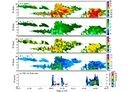
中文摘要: 利用常规天气资料,并结合第三次青藏高原大气科学试验(TIPEX Ⅲ)的毫米波云雷达资料和激光雨滴谱仪雨滴谱资料,对影响那曲地区的一次高原涡天气进行了综合分析,包括天气背景和云 降水水平、垂直结构和演变特征。结果表明:此次高原涡天气形成了涡旋状的云系,从垂直结构看本次过程由对流云演变为积层混合云。对流云阶段,回波多呈小面积的零星稀疏分布,持续时间较短,与此同时还伴有强烈的上升运动,云中正速度区多呈条状或细带状,云顶较高,呈“蘑菇状”,此时对应降水强度小,雨滴粒子浓度较低。混合云阶段,回波多呈整齐的片状,回波持续时间较长,云中的正速度区常呈柱状或方块状,近地面1 km位置处亮带明显,是由于粒子相态变化造成的,亮带以下降水粒子碰撞破碎,反射率因子明显降低,对应雨滴粒子直径多处于1~3 mm,且浓度较大。高原涡过程中不同阶段云所对应的雷达回波结构和降水特征存在明显的差别,本研究可为高原天气预报和物理过程等研究提供一定参考。
中文关键词: 青藏高原,那曲,高原涡,云降水,宏微观特征,云雷达
Abstract:In order to enhance the understanding of the macro and micro physical structures and characteristics of cloud-precipitation under the plateau vortex, conventional weather data, combined with the data of millimeter-wave cloud radar and rain droplet disdrometer from TDPEX-Ⅲ were used in this paper for comprehensive analysis of a plateau vortex weather which affected the Nagqu Region, including weather background, horizontal and vertical structures of cloud-precipitation and evolution characteristics. The conclusions are as follows. The vortex cloud system formed under the plateau vortex and this process evolved from convective clouds to cumulostratus mixed clouds. In the stage of convective clouds, echoes mostly distributed sparsely with small area and short duration, accompanied by strong ascending motion. The positive velocity zone in the cloud was mostly strips or thin strips, and the convective clouds had higher cloud top, which was “mushroom-shaped”. The rain intensity was weak and the concentration of droplet particles was low. In the stage of mixed clouds, the echoes were mostly in the form of regular patches with larger area and durations were longer. The positive velocity zone in the cloud were often columnar or block-shaped. Near the surface, bright bands were obvious, caused by the phase change of the particles. Due to the collision of the precipitation particles, the reflectivity factor below the bright band was significantly reduced. Droplets were mostly in the size of 1-3 mm with larger concentrations. Thus, there are obvious differences of radar echoes and precipitation features between different stages under the process of plateau vortex, and the finding might provide some references for the research of plateau weather forecasting and physical processes.
文章编号: 中图分类号: 文献标志码:
基金项目:国家自然科学基金项目(41705008)和国家重点研发计划(2018YFC1505702)共同资助
引用文本:
李筱杨,郑佳锋,朱克云,张杰,王雨琪,2019.基于雷达资料的一次高原涡天气云降水宏微观特征研究[J].气象,45(10):1415-1425.
LI Xiaoyang,ZHENG Jiafeng,ZHU Keyun,ZHANG Jie,WANG Yuqi,2019.Study of Macro and Micro Properties of Cloud and Precipitation Caused by Tibetan Plateau Vortex Based on Radar Observations[J].Meteor Mon,45(10):1415-1425.
李筱杨,郑佳锋,朱克云,张杰,王雨琪,2019.基于雷达资料的一次高原涡天气云降水宏微观特征研究[J].气象,45(10):1415-1425.
LI Xiaoyang,ZHENG Jiafeng,ZHU Keyun,ZHANG Jie,WANG Yuqi,2019.Study of Macro and Micro Properties of Cloud and Precipitation Caused by Tibetan Plateau Vortex Based on Radar Observations[J].Meteor Mon,45(10):1415-1425.