本文已被:浏览 1199次 下载 4875次
投稿时间:2018-01-28 修订日期:2019-03-20
投稿时间:2018-01-28 修订日期:2019-03-20
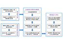
中文摘要: 介绍了城市近地面高分辨率快速风场模型的构建,以中尺度模式结果作为背景驱动场,5 m分辨率建筑物资料作为模型数据输入,通过区块处理、分区函数插值和质量守恒约束,实现了在较短时间(2~3 h)内获得可覆盖城市尺度的高分辨率(10 m左右)的近地面风场。基于该模型对北京四环内主城区(20 km×19 km)在8个典型时刻的10 m分辨率风场进行了模拟和检验,结果如下:(1)在风速方面,模拟值与观测值相比往往会偏大些,夏季4个时刻模拟的准确率在90%以上,冬季4个时刻模拟的准确率在60%以上;在风向方面,8个时刻的准确率均在40%以上。(2)基于该风场模型模拟得到的高分辨率风场能够反映出北京主城区风的山谷风日变化特征;明显的风速大值区往往对应着粗糙度较小的下垫面,而一些密集高层建筑区域始终是流场凌乱的风速小值区。(3)以东二环某一区块为例,该高分辨率风场模型还可对重点街区的精细化风场特征进行展示,可以清晰地反映出流场因建筑物分布产生的分流、汇合、局部环流,以及尾流。综上所述,该城市风场模型为实现短时间内获得覆盖城市尺度的高分辨率近地面风场提供了有效途径。掌握城市尺度的精细化风环境特征,有助于识别亟需改善或限制开发的关键区域,辅助城市通风廊道的合理构建和实施,从而达到优化城市内部通风性能、缓解城市热岛、增加风环境舒适度的最终目标。
中文关键词: 风场模型,高分辨率,下垫面,建筑
Abstract:This paper introduces the construction of the Urban Surface High-resolution and Fast Wind Field (USHFWF) model, which uses the mesoscale model simulation as the background field and 5 m resolution building data as the model input data. The USHFWF model is developed through block processing, spatial interpolation based on partition function and mass conservation constraint, in order to achieve the near-surface wind field with a high resolution (horizontal resolution of 10 m×10 m grid) covering city scale over a short period of time (about 2-3 h). Based on this model, wind field with 10 m resolution in downtown of Beijing (i.e. within Fourth Ring Road, 20 km×19 km) is simulated and validated at 8 typical times. The main results are as follows: (1) In terms of wind speed, the simulation is usually larger than the observed values. The accuracy rates of the four times in summer and winter are more than 90% and 60%, respectively. In terms of wind direction, the accuracy rate of the eight times is all more than 40%. (2) The high-resolution wind field simulated by USHFWF model reflects the diurnal variation characteristics of wind in the central part of Beijing. Obviously, the area with large wind speed usually corresponds to the underlying surface with less roughness, and the area with small wind speed and disturbed flow usually corresponds to the underlying surface with high-density or high-rise buildings. (3) The USHFWF model can also show fine scale characteristics of the key block’s wind field. Take a block near the East Second Ring Road as an example. The simulated wind field can clearly reflect the flow due to the distribution of buildings, such as diffluence, confluence, local circulation, and wake flow. In summary, USHFWF model provides an effective way to obtain high-resolution near surface wind field covering urban scale in a short time. It is helpful to identify the key areas that need to be improved or restricted to development, and to facilitate the rational construction and implementation of the urban ventilation corridors, so as to achieve the ultimate goal of optimizing the internal ventilation performance, alleviate the urban heat island effect and improve the wind-environment comfort.
文章编号: 中图分类号:X16 文献标志码:
基金项目:中国气象局气候变化专项(CCSF201733)、北京市气象局科技项目(BMBKJ201704004)及国家自然科学基金项目(41675008和51538005)共同资助
引用文本:
邢佩,房小怡,张宁,程宸,王昕瑶,刘勇洪,杜吴鹏,杨若子,党冰,2019.城市近地面高分辨率快速风场模型构建与应用[J].气象,45(7):978-988.
XING Pei,FANG Xiaoyi,ZHANG Ning,CHENG Chen,WANG Xinyao,LIU Yonghong,DU Wupeng,YANG Ruozi,DANG Bing,2019.Construction and Application of the Urban Surface High-Resolution and Fast Wind Field Model[J].Meteor Mon,45(7):978-988.