本文已被:浏览 1271次 下载 5290次
投稿时间:2018-05-11 修订日期:2018-08-29
投稿时间:2018-05-11 修订日期:2018-08-29
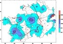
中文摘要: 利用2016—2017年自动站逐小时观测资料,统计分析了贵州大雾天气的时空分布特征;同时,结合天气图资料分析筛选了锋面大雾个例31 d和辐射大雾个例17 d,对比分析大雾生消过程中风、温、湿等气象要素演变特点。结果表明:(1)贵州大雾在秋末到初春较为频发;一天中夜间02—09时是大雾频发时段,07时达到峰值。(2)贵州自西向东有4个多雾区,分别为西南部区域、中部区域、东部边缘区域和北部局部区域。(3)锋面大雾主要出现在贵州中西部,范围最广时可达20个县站左右,持续时长可达10~13 h,单站可持续60 h以上。辐射大雾以贵州中东部地区出现较多,范围最广时可接近40个县站,远比锋面大雾范围广,持续时间相对较短。(4)大雾期间,10 min平均风速为0~3 m?s-1,相对湿度为97%~100%,温度露点差为0~0.5℃;辐射大雾初期或形成前气温呈下降状态,消散期升温较明显,地气温差呈现由负到正或由低到高的变化趋势,反映出近地层大气由较为稳定的逆温环境向不稳定环境变化的过程;锋面大雾初期的降温和后期的升温现象并不突出,地气温差也没有特定的变化规律,仅有部分个例与锋面大雾情况一致。
中文关键词: 大雾,自动观测,时空分布,气象要素,锋面,辐射
Abstract:The hourly observation data of automatic station in Guizhou Province from 2016 to 2017 were used to analyze the spatio temporal distribution characteristics of heavy fog. Meanwhile, 31 days of front fog and 17 days of radiation fog were screened out via analyzing the synoptic data, and the evolution characteristics of meteorological elements such as wind, temperature and humidity were compared and analyzed. The results are as follows. (1) Heavy fog happens frequently in late autumn and early spring in Guizhou. The occurrence time period of the highest frequency is from 02:00 to 09:00 BT, reaching the peak at 07:00 BT. (2) The southwest, central, eastern and northern parts of Guizhou are the foggy areas from west to east. (3) Frontal fog mainly appears in the central and western Guizhou. The most extensive range covers about 20 county stations, and the duration can be 10-13 h. Some single station can have fog more than 60 h. Radiation fog mainly appears in the central and eastern Guizhou. The widest range can be close to 40 county stations, far more than the frontal fog range, and the duration is relatively short. (4) The 10 min average wind speed is 0-3 m?s-1, the relative humidity is 97%-100%, and the difference between temperature and dew point is 0-0.5℃. Temperature is in a state of decline at the beginning or before the formation of fog. In the period of extinction, warming is more obvious. The difference in temperature between surface and atmosphere presents a trend from negative to positive or from low to high, which reflects the process in which the near surface atmosphere changes from a more stable inversion temperature environment to an unstable environment. The early cooling and later heating up are not obvious in frontal fog, also the temperature has no regular distribution between ground surface and atmosphere, only some cases are in line with frontal fog.
文章编号: 中图分类号: 文献标志码:
基金项目:贵州省科技计划项目(黔科合支撑[2017]2812)、中国气象局预报员专项(CMAYBY2017 067)共同资助
| 作者 | 单位 |
| 胡跃文 | 贵州省气象学会,贵阳 550002 |
| 秦杰 | 贵州省清镇市气象局,清镇 551400 |
| 苏静文 | 贵州省气象服务中心,贵阳 550002 |
| 牛迪宇 | 贵州省气象服务中心,贵阳 550002 |
| 吉廷艳 | 贵州省气象服务中心,贵阳 550002 |
引用文本:
胡跃文,秦杰,苏静文,牛迪宇,吉廷艳,2019.2016—2017年贵州大雾时空分布及气象要素演变分析[J].气象,45(5):659-666.
HU Yuewen,QIN Jie,SU Jingwen,NIU Diyu,JI Tingyan,2019.Analysis of Heavy Fog Spatio Temporal Distribution and Meteorological Element Evolution in Guizhou from 2016 to 2017[J].Meteor Mon,45(5):659-666.
胡跃文,秦杰,苏静文,牛迪宇,吉廷艳,2019.2016—2017年贵州大雾时空分布及气象要素演变分析[J].气象,45(5):659-666.
HU Yuewen,QIN Jie,SU Jingwen,NIU Diyu,JI Tingyan,2019.Analysis of Heavy Fog Spatio Temporal Distribution and Meteorological Element Evolution in Guizhou from 2016 to 2017[J].Meteor Mon,45(5):659-666.