本文已被:浏览 1682次 下载 4085次
投稿时间:2018-01-17 修订日期:2018-08-17
投稿时间:2018-01-17 修订日期:2018-08-17
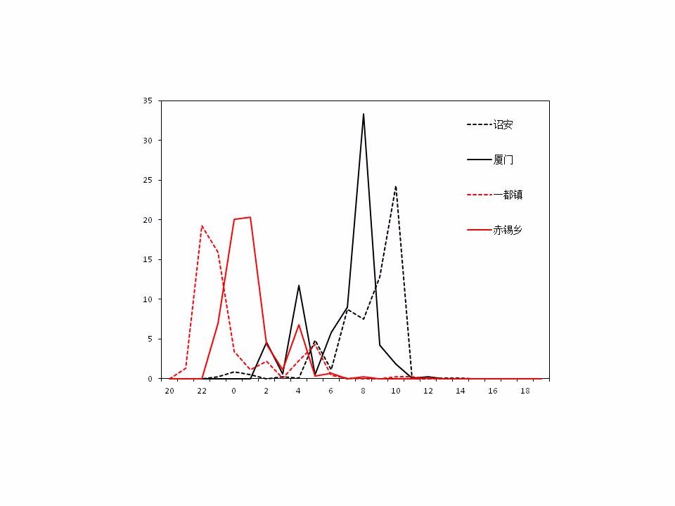
中文摘要: 利用福建省逐小时加密自动站资料、风廓线、S波段双偏振雷达与雨滴谱等新型探测资料以及NCEP逐6 h的1°×1°大气再分析资料,分析了2017年2月21—22日福建中南部一次预报失败的冬季暴雨过程。结果表明:(1)此次暴雨过程类似于锋前暖区暴雨,自2000年以来仅此一例,十分罕见,是在低空急流偏强并长时间维持的背景下产生的,并未受到南支槽和冷空气的影响。(2)闽中大到暴雨带和闽南暴雨区的对流系统相互独立,有多个对流系统影响闽中地区,仅两个对流系统影响闽南地区。降水有较明显对流特征,属暖云弱对流降水,容易导致预报员对雨强估计不足。(3)此次冬季暴雨过程的水汽主要来自南海地区,低层水汽条件与汛期暴雨相当,但整层水汽条件较汛期略差;低空急流对暖湿气流的输送使暴雨区趋于不稳定,但对流不稳定度较汛期弱。(4)高空辐散低层辐合的配置为冬季暴雨带来了有利的动力抬升条件,但暴雨区涡旋性不强,无明显正涡度柱。其中,闽中大到暴雨主要与条件性对称不稳定有关,是在湿斜压作用下倾斜上升运动中产生,而闽南暴雨区既存在对流不稳定,也存在条件性对称不稳定。
中文关键词: 冬季锋前暴雨,微物理特征,低空急流,水汽,湿位涡
Abstract:Based on Fujian dense automatic station data, wind profile radar data, S band dual polarization radar data, raindrop spectrum data and NCEP 1°×1° reanalysis data, the failed forecast of winter torrential rain for central and southern Fujian from 20:00 BT 21 to 20:00 BT 22 February 2017 is analyzed. The results suggest that: (1) The uncommon torrential rain happened ahead of the front, under the background of strong and long persisting low level jet, seen only once since 2000, and was not affected by the southern trough and cold air. (2) Convective systems in central and southern Fujian were independent to each other, and multiple convective systems affected central Fujian, but only two affected southern Fujian. The convective precipitation was warm rain process convection, easily causing the underestimation of rainfall intensity. (3) The water vapor came mainly from the South China Sea. Compared with heavy rain events in flood season, the low level water vapor condition was similar to that of flood season although water vapor in the whole layer was slightly weaker. Warm and wet air transport by low level jet increased the instability of stratification in rainstorm area, but the convective instability was slightly weaker than that in the flood season. (4) Divergence at upper layer coupling with low layer convergence provided favorable condition for the dynamic lifting of rainstorm areas, but the wind vorticity was not strong and there was no obvious positive vorticity column. Analysis of wet potential vorticity indicates that the heavy to trorrential rain in central Fujian was mainly related to conditional symmetric instability, resulting in the inclining ascending motion, but both convective instability and conditional symmetric instability played great roles in the rainstorm area in southern Fujian.
文章编号: 中图分类号: 文献标志码:
基金项目:国家自然科学基金项目(41675047)资助
| 作者 | 单位 |
| 陈健康 | 海峡气象开放实验室,厦门 361012 厦门市气象台,厦门 361012 |
| 赵玉春 | 海峡气象开放实验室,厦门 361012 |
| 陈赛 | 厦门市气象台,厦门 361012 |
| 黄惠镕 | 厦门市气象台,厦门 361012 |
| 郑辉 | 厦门市气象台,厦门 361012 |
引用文本:
陈健康,赵玉春,陈赛,黄惠镕,郑辉,2019.闽中南罕见冬季锋前暴雨个例特征分析[J].气象,45(2):228-239.
CHEN Jiankang,ZHAO Yuchun,CHEN Sai,HUANG Huirong,ZHENG Hui,2019.Characteristic Analysis on a Winter Prefrontal Torrential Rain in Central and Southern Fujian[J].Meteor Mon,45(2):228-239.
陈健康,赵玉春,陈赛,黄惠镕,郑辉,2019.闽中南罕见冬季锋前暴雨个例特征分析[J].气象,45(2):228-239.
CHEN Jiankang,ZHAO Yuchun,CHEN Sai,HUANG Huirong,ZHENG Hui,2019.Characteristic Analysis on a Winter Prefrontal Torrential Rain in Central and Southern Fujian[J].Meteor Mon,45(2):228-239.


