本文已被:浏览 2217次 下载 4131次
投稿时间:2018-07-05 修订日期:2018-08-27
投稿时间:2018-07-05 修订日期:2018-08-27
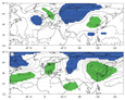
中文摘要: 2018年春季全国平均气温为1961年来最高,全国大部地区气温普遍偏高,尤其是长江以南及中国北方的中部区域偏高明显。全国平均降水量较常年略偏多,呈东部地区“南少北多”,华西降水偏多,而江南南部至华南、西北西部的部分地区降水偏少的分布特点。自北大西洋经欧亚大陆至东北亚中高纬上空的纬向波列及东亚低层维持的异常偏南气流是2018年春季中国气候异常的重要原因,且乌拉尔山以东的低槽和东北亚上空的高脊是关键环流系统。亚洲中低纬上空均为异常高压脊控制,尤其是东北亚上空的高脊造成了2018年春季中国大部地区气温偏高。乌拉尔山以东低槽有利于冷空气爆发南下而东北亚上空的高脊引导西北太平洋暖湿气流向西向北影响我国,冷暖气流交汇从而造成了长江以北地区及华西降水偏多,而南海至西太平洋上空的异常气旋则导致江南南部至华南少雨。另外,虽然2017/2018年冬季发生了一次弱的La Ni〖AKn~D〗a事件,并且2018年春季北大西洋三极子模态(NAT)呈较强的正位相,但其对中国2018年春季降水异常影响较小,而以大气环流的影响为主导。进一步分析发现,乌拉尔山以东的低槽和东北亚上空的高脊与中国春季温度和降水具有很好的相关性,易于造成中国气温偏高;东部降水“南少北多”且华西多雨。两个关键环流系统间存在显著的负相关关系,且均与欧亚遥相关(EU)波列关系密切。同时,东北亚上空的脊还与北极涛动(AO)正位相具有高相关。
中文关键词: 春季气候异常,中高纬环流,乌拉尔山以东槽,东北亚脊
Abstract:From March to May 2018, the mean temperature in China ranks the highest since 1961. The temperature is almost above normal in China, with the warmest regions located to the south of the Yangtze River and the central part of northern China. The mean precipitation of China is a little above normal. For eastern China, the precipitation is more than normal to the north of Yangtze River while it is less than normal to the south. As for western China, the positive anomalies of precipitation are observed in most parts of Southwest China, southeastern part of Northwest China and northern and western Xinjiang, while the negative anomalies are mainly in southern Xinjiang, western Qinghai and northwestern Gansu. The zonal wave train stretching from North Atlantic to Northeast Asia via Eurasia Continent at the mid high latitudes mainly contributes to the climate anomalies in China from March to May 2018, with the trough to the east of Ural Mountains and the ridge over Northeast Asia occupying the key circulations. The anomalous high pressure, especially the ridge over Northeast Asia controls the extensive regions over the mid low latitudes of Asia to cause the higher than normal temperature over most China from March to May 2018. The trough to the east of Ural Mountains favors the southward outbreak of the cold air, while the ridge over Northeast Asia leads the moisture to transport westward and northward from the western Pacific. Then, the cold and dry air mass merges with the warm and moist one to form the above normal precipitation over the region to the north of the Yangtze River and West China. Meanwhile, the anomalous cyclonic circulation over the South China Sea and the tropical western Pacific contributes to the below normal precipitation from the region to the south of the Yangtze River to South China. Though a weak La Ni〖AKn~D〗a event occurs during the winter of 2017/2018 and the positive phase of North Atlantic Triple (NAT) mode persists from March to May 2018, they put limited impacts on the 2018s spring rainfall anomalies in China but the circulations dominate. Further analyses present that the intensity of the the trough to the east of Ural Mountains and the ridge over Northeast Asia has high correlations with both temperature and precipitation of China during spring, favoring the above normal temperature in most of China and more than normal precipitation in West China and to the north of the Yangtze River but less than normal precipitation to the south. Significant negative correlation exists between the intensity of the two circulations and they are both closely connected with the Eurasian (EU) teleconnection pattern. Moreover, the ridge over Northeast Asia is also highly correlated with the positive phase of AO.
文章编号: 中图分类号: 文献标志码:
基金项目:国家自然科学基金项目(41675069)和国家重点研发计划(2016YFA0600701)共同资助
| 作者 | 单位 |
| 王遵娅 | 国家气候中心,北京 100081 |
| 柳艳菊 | 国家气候中心,北京 100081 |
| 丁婷 | 国家气候中心,北京 100081 |
| 李多 | 国家气候中心,北京 100081 |
| 洪洁莉 | 国家气候中心,北京 100081 |
引用文本:
王遵娅,柳艳菊,丁婷,李多,洪洁莉,2018.2018年春季气候异常及可能成因分析[J].气象,44(10):1360-1369.
WANG Zunya,LIU Yanju,DING Ting,LI Duo,HONG Jieli,2018.Features and Possible Causes for the Climate Anomalies in Spring 2018[J].Meteor Mon,44(10):1360-1369.
王遵娅,柳艳菊,丁婷,李多,洪洁莉,2018.2018年春季气候异常及可能成因分析[J].气象,44(10):1360-1369.
WANG Zunya,LIU Yanju,DING Ting,LI Duo,HONG Jieli,2018.Features and Possible Causes for the Climate Anomalies in Spring 2018[J].Meteor Mon,44(10):1360-1369.