本文已被:浏览 1675次 下载 4450次
投稿时间:2018-02-11 修订日期:2018-03-19
投稿时间:2018-02-11 修订日期:2018-03-19
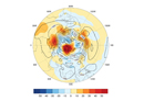
中文摘要: 根据国家气象信息中心提供的中国台站气温、降水资料,NCEP/NCAR逐日大气环流再分析资料和NOAA提供的月平均海温资料,分析了2017年秋季我国北方地区降水异常偏多的成因。结果表明2017年秋季我国降水阶段性特征明显,9—10月北方地区降水异常偏多主要受东亚环流型组合异常的影响。东亚500 hPa高度距平场从高纬至低纬呈“+-+”的异常分布,极区高度场偏高,极涡分裂偏向东北亚地区,贝加尔湖 巴尔喀什湖地区为显著低槽区,西太平洋副热带高压较常年偏强偏西偏北,有利于华西秋雨偏强。此外,850 hPa距平风场上朝鲜半岛的反气旋式环流异常有利于引导偏东路径的冷湿气流输送至黄河与长江之间的地区,与来自孟加拉湾和南海的暖湿气流交汇,形成水汽通量异常辐合区,造成黄淮及江淮等地降水异常偏多。进一步诊断表明热带中东太平洋海温秋季转为偏冷状态,热带太平洋地区Walker环流明显增强,有利于西太平洋副热带高压偏强西伸偏北;9—10月热带印度洋偶极子维持正位相有利于在孟加拉湾形成反气旋式环流异常,并同样有利于副热带高压西伸偏北。因此,海温外强迫信号的影响加上中高纬环流异常的共同作用造成9—10月东亚环流型异常特征,并进一步导致我国北方地区降水异常偏多。
中文关键词: 秋季降水,北方地区,西太平洋副热带高压,海温异常
Abstract:The stage characteristics of precipitation over China in the autumn of 2017 is obvious, and the significantly above-normal precipitation over northern China from September to October was mainly influenced by the East Asia circulation pattern anomaly. The distribution of 500 hPa height anomaly field in East Asia was “+-+” from high to low latitude. The polar height field was higher than normal, the polar vortex split and inclined to Northeast Asia, the area between Baikal Lake and Balkhash Lake was under a significantly low trough, and the West Pacific subtropical high was stronger, stretching more westward and northward than normal, which is favorable to the intensive autumn rainfall in West China. In addition, anticyclonic circulation anomaly over Korean Peninsula was conducive to guiding the cold and wet airflow along the easterly path to the area between the Yellow River and the Yangtze River, and to converging with the warm and wet airflow from the Bay of Bengal and the South China Sea. The water vapor flux convergence resulted in precipitation anomalies in the Huanghuai and Jianghuai regions. Further diagnosis shows that the tropical Middle East Pacific sea surface temperature turned cold in autumn, and the Walker circulation in the tropical Pacific increased obviously, which is beneficial to the westward and northward extension of the stronger West Pacific subtropical high. The positive phase of the tropical Indian Ocean dipole in September-October was favorable for the formation of anticyclonic circulation anomalies in the Bay of Bengal, and also beneficial to the westward and northward extension of the West Pacific subtropical high. Therefore, the influence of the external forcing signal of sea surface temperature and the circulation anomaly in the middle and high latitudes over East Asia led to more precipitation over northern China.
文章编号: 中图分类号: 文献标志码:
基金项目:国家自然科学基金面上项目(41575074)、国家重点基础研究发展计划(973计划)(2015CB453203)和国家自然科学基金重点项目(41730964)共同资助
| 作者 | 单位 |
| 支蓉 | 国家气候中心,中国气象局气候研究开放实验室,北京 100081 |
| 陈丽娟 | 1 国家气候中心,中国气象局气候研究开放实验室,北京 100081 2 南京信息工程大学气象灾害预报预警与评估协同创新中心,南京 210044 |
| 竺夏英 | 国家气候中心,中国气象局气候研究开放实验室,北京 100081 |
引用文本:
支蓉,陈丽娟,竺夏英,2018.2017年秋季我国北方地区降水异常偏多成因分析[J].气象,44(4):572-581.
ZHI Rong,CHEN Lijuan,ZHU Xiaying,2018.Analysis of Characteristics and Causes of Precipitation Anomalies over Northern China in Autumn 2017[J].Meteor Mon,44(4):572-581.
支蓉,陈丽娟,竺夏英,2018.2017年秋季我国北方地区降水异常偏多成因分析[J].气象,44(4):572-581.
ZHI Rong,CHEN Lijuan,ZHU Xiaying,2018.Analysis of Characteristics and Causes of Precipitation Anomalies over Northern China in Autumn 2017[J].Meteor Mon,44(4):572-581.